HDA Harding Lake, AK, USA - Earthquake Result Viewer
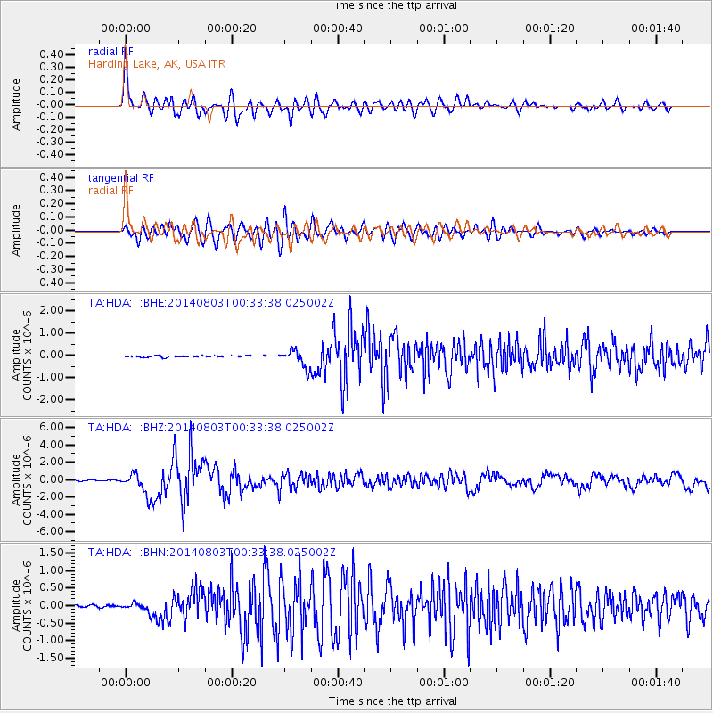
Earthquake location: E. Caroline Islands, Micronesia
Earthquake latitude/longitude: 0.8/146.1
Earthquake time(UTC): 2014/08/03 (215) 00:22:03 GMT
Earthquake Depth: 11 km
Earthquake Magnitude: 6.9 MWW, 6.8 MWB, 6.9 MWC, 7.2 MI
Earthquake Catalog/Contributor: NEIC PDE/NEIC COMCAT
Network: TA USArray Transportable Network (new EarthScope stations)
Station: HDA Harding Lake, AK, USA
Lat/Lon: 64.41 N/146.95 W
Elevation: 437 m
Distance: 79.4 deg
Az: 23.979 deg
Baz: 249.335 deg
Ray Param: 0.0489678
Estimated Moho Depth: 55.25 km
Estimated Crust Vp/Vs: 1.88
Assumed Crust Vp: 6.566 km/s
Estimated Crust Vs: 3.488 km/s
Estimated Crust Poisson's Ratio: 0.30
Radial Match: 87.214584 %
Radial Bump: 400
Transverse Match: 83.2245 %
Transverse Bump: 400
SOD ConfigId: 769524
Insert Time: 2014-08-17 00:59:19.498 +0000
GWidth: 2.5
Max Bumps: 400
Tol: 0.001

Signal To Noise

ChannelStoNSTALTA
TA:HDA: :BHZ:20140803T00:33:38.025002Z24.682361.2425984E-65.034358E-8
TA:HDA: :BHN:20140803T00:33:38.025002Z3.63350631.2166706E-73.3484753E-8
TA:HDA: :BHE:20140803T00:33:38.025002Z12.0291193.977909E-73.3068996E-8
Arrivals
Ps7.6 SECOND
PpPs24 SECOND
PsPs/PpSs31 SECOND