You are here: Home > Network List > II - Global Seismograph Network (GSN - IRIS/IDA) Stations List
> Station CMLA Cha de Macela, Sao Miguel Island, Azores > Earthquake Result Viewer
CMLA Cha de Macela, Sao Miguel Island, Azores - Earthquake Result Viewer
| Earthquake location: |
Hindu Kush Region, Afghanistan |
| Earthquake latitude/longitude: |
36.4/70.9 |
| Earthquake time(UTC): |
1997/05/13 (133) 14:13:45 GMT |
| Earthquake Depth: |
196 km |
| Earthquake Magnitude: |
6.1 MB, 6.5 UNKNOWN, 6.4 MW |
| Earthquake Catalog/Contributor: |
WHDF/NEIC |
|
| Network: |
II Global Seismograph Network (GSN - IRIS/IDA) |
| Station: |
CMLA Cha de Macela, Sao Miguel Island, Azores |
| Lat/Lon: |
37.76 N/25.52 W |
| Elevation: |
429 m |
|
| Distance: |
73.2 deg |
| Az: |
304.672 deg |
| Baz: |
56.836 deg |
| Ray Param: |
0.052608974 |
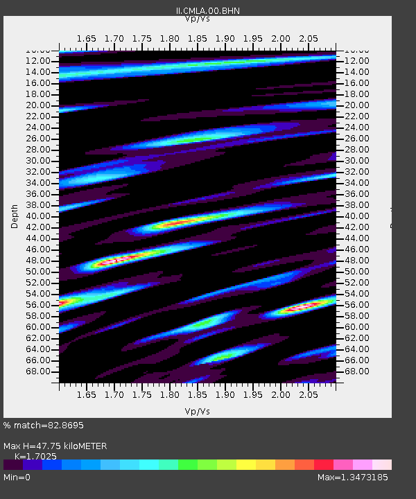
| Estimated Moho Depth: |
47.75 km |
| Estimated Crust Vp/Vs: |
1.70 |
| Assumed Crust Vp: |
4.802 km/s |
| Estimated Crust Vs: |
2.821 km/s |
| Estimated Crust Poisson's Ratio: |
0.24 |
|
| Radial Match: |
82.8695 % |
| Radial Bump: |
400 |
| Transverse Match: |
83.550896 % |
| Transverse Bump: |
400 |
| SOD ConfigId: |
6273 |
| Insert Time: |
2010-03-02 00:40:00.899 +0000 |
| GWidth: |
2.5 |
| Max Bumps: |
400 |
| Tol: |
0.001 |
|
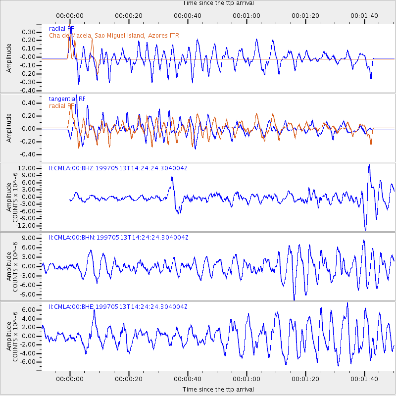
Signal To Noise
| Channel | StoN | STA | LTA |
| II:CMLA:00:BHN:19970513T14:24:24.304004Z | 1.9861586 | 1.5780746E-6 | 7.9453605E-7 |
| II:CMLA:00:BHE:19970513T14:24:24.304004Z | 0.6201846 | 7.946495E-7 | 1.2813113E-6 |
| II:CMLA:00:BHZ:19970513T14:24:24.304004Z | 3.6333764 | 2.9884397E-6 | 8.224966E-7 |
| Arrivals |
| Ps | 7.1 SECOND |
| PpPs | 26 SECOND |
| PsPs/PpSs | 33 SECOND |


