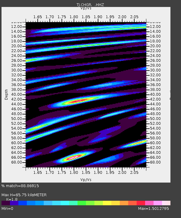
CHGR Chuyangaron, Tajikistan - Earthquake Result Viewer

Earthquake location: E. Caroline Islands, Micronesia
Earthquake latitude/longitude: 0.8/146.1
Earthquake time(UTC): 2014/08/03 (215) 00:22:03 GMT
Earthquake Depth: 11 km
Earthquake Magnitude: 6.9 MWW, 6.8 MWB, 6.9 MWC, 7.2 MI
Earthquake Catalog/Contributor: NEIC PDE/NEIC COMCAT
Network: TJ Tajikistan National Seismic Network
Station: CHGR Chuyangaron, Tajikistan
Lat/Lon: 38.66 N/69.16 E
Elevation: 1049 m
Distance: 79.3 deg
Az: 309.078 deg
Baz: 97.521 deg
Ray Param: 0.04904315
Estimated Moho Depth: 65.75 km
Estimated Crust Vp/Vs: 1.80
Assumed Crust Vp: 6.483 km/s
Estimated Crust Vs: 3.601 km/s
Estimated Crust Poisson's Ratio: 0.28
Radial Match: 88.86915 %
Radial Bump: 400
Transverse Match: 77.682304 %
Transverse Bump: 400
SOD ConfigId: 769524
Insert Time: 2014-08-17 01:00:57.583 +0000
GWidth: 2.5
Max Bumps: 400
Tol: 0.001

Signal To Noise

ChannelStoNSTALTA
TJ:CHGR: :HHZ:20140803T00:33:37.429971Z43.298413.9713773E-69.1721084E-8
TJ:CHGR: :HHN:20140803T00:33:37.429971Z2.40976362.5732044E-71.0678244E-7
TJ:CHGR: :HHE:20140803T00:33:37.429971Z13.1178431.1219903E-68.553161E-8
Arrivals
Ps8.4 SECOND
PpPs28 SECOND
PsPs/PpSs36 SECOND