You are here: Home > Network List > TA - USArray Transportable Network (new EarthScope stations) Stations List
> Station G59A Clarenceville, QC, USA > Earthquake Result Viewer
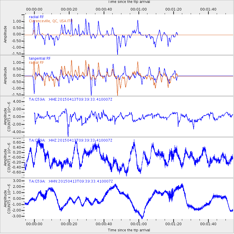
G59A Clarenceville, QC, USA - Earthquake Result Viewer
*The percent match for this event was below the threshold and hence no stack was calculated.
| Earthquake location: |
Afghanistan-Tajikistan Bord Reg. |
| Earthquake latitude/longitude: |
36.5/71.4 |
| Earthquake time(UTC): |
2015/04/13 (103) 09:27:03 GMT |
| Earthquake Depth: |
96 km |
| Earthquake Magnitude: |
4.8 MW, 4.7 mb |
| Earthquake Catalog/Contributor: |
ISC/ISC |
|
| Network: |
TA USArray Transportable Network (new EarthScope stations) |
| Station: |
G59A Clarenceville, QC, USA |
| Lat/Lon: |
45.08 N/73.18 W |
| Elevation: |
36 m |
|
| Distance: |
92.7 deg |
| Az: |
335.726 deg |
| Baz: |
27.884 deg |
| Ray Param: |
$rayparam |
*The percent match for this event was below the threshold and hence was not used in the summary stack. |
|
| Radial Match: |
69.76688 % |
| Radial Bump: |
268 |
| Transverse Match: |
60.202377 % |
| Transverse Bump: |
400 |
| SOD ConfigId: |
7422571 |
| Insert Time: |
2019-04-18 04:23:19.424 +0000 |
| GWidth: |
2.5 |
| Max Bumps: |
400 |
| Tol: |
0.001 |
|
Signal To Noise
| Channel | StoN | STA | LTA |
| TA:G59A: :HHZ:20150413T09:39:33.410007Z | 1.5033995 | 4.5971234E-7 | 3.057819E-7 |
| TA:G59A: :HHN:20150413T09:39:33.410007Z | 4.1503615 | 1.1327874E-6 | 2.7293703E-7 |
| TA:G59A: :HHE:20150413T09:39:33.410007Z | 0.8575588 | 9.2954997E-7 | 1.083949E-6 |
| Arrivals |
| Ps | |
| PpPs | |
| PsPs/PpSs | |


