MRBL Marblemount, WA, USA - Earthquake Result Viewer
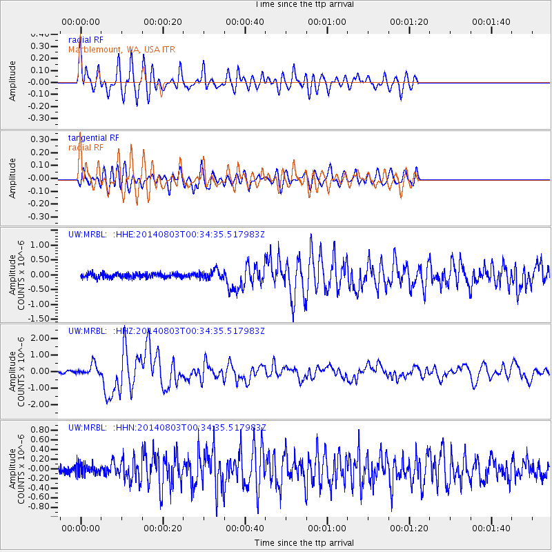
Earthquake location: E. Caroline Islands, Micronesia
Earthquake latitude/longitude: 0.8/146.1
Earthquake time(UTC): 2014/08/03 (215) 00:22:03 GMT
Earthquake Depth: 11 km
Earthquake Magnitude: 6.9 MWW, 6.8 MWB, 6.9 MWC, 7.2 MI
Earthquake Catalog/Contributor: NEIC PDE/NEIC COMCAT
Network: UW Pacific Northwest Regional Seismic Network
Station: MRBL Marblemount, WA, USA
Lat/Lon: 48.52 N/121.48 W
Elevation: 75 m
Distance: 90.9 deg
Az: 41.636 deg
Baz: 272.329 deg
Ray Param: 0.041636772
Estimated Moho Depth: 27.5 km
Estimated Crust Vp/Vs: 2.01
Assumed Crust Vp: 6.566 km/s
Estimated Crust Vs: 3.267 km/s
Estimated Crust Poisson's Ratio: 0.34
Radial Match: 86.25947 %
Radial Bump: 400
Transverse Match: 75.39699 %
Transverse Bump: 400
SOD ConfigId: 769524
Insert Time: 2014-08-17 01:04:49.967 +0000
GWidth: 2.5
Max Bumps: 400
Tol: 0.001

Signal To Noise

ChannelStoNSTALTA
UW:MRBL: :HHZ:20140803T00:34:35.517983Z6.09057433.5518283E-75.8316807E-8
UW:MRBL: :HHN:20140803T00:34:35.517983Z1.4788461.0449853E-77.066222E-8
UW:MRBL: :HHE:20140803T00:34:35.517983Z2.02399441.5222169E-77.520856E-8
Arrivals
Ps4.3 SECOND
PpPs12 SECOND
PsPs/PpSs17 SECOND