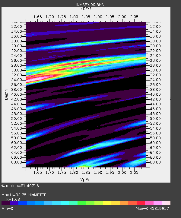
MSEY Mahe, Seychelles - Earthquake Result Viewer

Earthquake location: Eastern New Guinea Reg., P.N.G.
Earthquake latitude/longitude: -5.5/147.9
Earthquake time(UTC): 1997/12/22 (356) 02:05:50 GMT
Earthquake Depth: 179 km
Earthquake Magnitude: 6.3 MB, 6.7 MS, 7.1 UNKNOWN, 7.0 ME
Earthquake Catalog/Contributor: WHDF/NEIC
Network: II Global Seismograph Network (GSN - IRIS/IDA)
Station: MSEY Mahe, Seychelles
Lat/Lon: 4.67 S/55.48 E
Elevation: 475 m
Distance: 91.9 deg
Az: 265.149 deg
Baz: 95.637 deg
Ray Param: 0.04145302
Estimated Moho Depth: 33.75 km
Estimated Crust Vp/Vs: 1.63
Assumed Crust Vp: 6.303 km/s
Estimated Crust Vs: 3.867 km/s
Estimated Crust Poisson's Ratio: 0.20
Radial Match: 81.40716 %
Radial Bump: 400
Transverse Match: 46.08027 %
Transverse Bump: 400
SOD ConfigId: 4480
Insert Time: 2010-03-02 00:40:22.402 +0000
GWidth: 2.5
Max Bumps: 400
Tol: 0.001

Signal To Noise

ChannelStoNSTALTA
II:MSEY:00:BHN:19971222T02:18:06.77002Z2.91989161.0162056E-63.4802855E-7
II:MSEY:00:BHE:19971222T02:18:06.77002Z2.72314127.6549827E-72.8110856E-7
II:MSEY:00:BHZ:19971222T02:18:06.77002Z1.15527374.1776704E-73.616174E-7
Arrivals
Ps3.4 SECOND
PpPs14 SECOND
PsPs/PpSs17 SECOND