You are here: Home > Network List > II - Global Seismograph Network (GSN - IRIS/IDA) Stations List
> Station MSEY Mahe, Seychelles > Earthquake Result Viewer
MSEY Mahe, Seychelles - Earthquake Result Viewer

| Earthquake location: |
Cyprus Region |
| Earthquake latitude/longitude: |
34.6/32.1 |
| Earthquake time(UTC): |
1996/10/09 (283) 13:10:52 GMT |
| Earthquake Depth: |
33 km |
| Earthquake Magnitude: |
6.4 MB, 6.8 MS, 7.2 UNKNOWN, 6.8 MW |
| Earthquake Catalog/Contributor: |
WHDF/NEIC |
|
| Network: |
II Global Seismograph Network (GSN - IRIS/IDA) |
| Station: |
MSEY Mahe, Seychelles |
| Lat/Lon: |
4.67 S/55.48 E |
| Elevation: |
475 m |
|
| Distance: |
44.8 deg |
| Az: |
145.896 deg |
| Baz: |
332.336 deg |
| Ray Param: |
0.07162886 |
| Estimated Moho Depth: |
32.25 km |
| Estimated Crust Vp/Vs: |
1.66 |
| Assumed Crust Vp: |
6.303 km/s |
| Estimated Crust Vs: |
3.785 km/s |
| Estimated Crust Poisson's Ratio: |
0.22 |
|
| Radial Match: |
94.40243 % |
| Radial Bump: |
262 |
| Transverse Match: |
87.78974 % |
| Transverse Bump: |
400 |
| SOD ConfigId: |
6273 |
| Insert Time: |
2010-03-02 00:40:24.081 +0000 |
| GWidth: |
2.5 |
| Max Bumps: |
400 |
| Tol: |
0.001 |
|
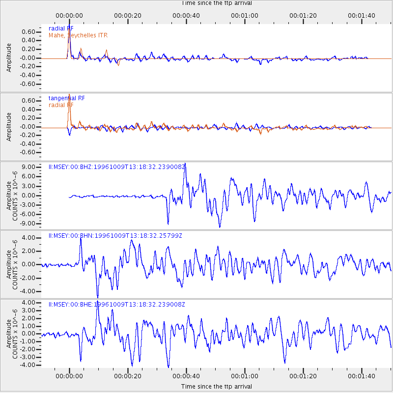
Signal To Noise
| Channel | StoN | STA | LTA |
| II:MSEY:00:BHN:19961009T13:18:32.25799Z | 9.098283 | 1.2282103E-6 | 1.3499363E-7 |
| II:MSEY:00:BHE:19961009T13:18:32.239008Z | 6.187371 | 1.0386523E-6 | 1.6786652E-7 |
| II:MSEY:00:BHZ:19961009T13:18:32.239008Z | 13.977628 | 2.6009022E-6 | 1.8607608E-7 |
| Arrivals |
| Ps | 3.6 SECOND |
| PpPs | 13 SECOND |
| PsPs/PpSs | 16 SECOND |


