You are here: Home > Network List > II - Global Seismograph Network (GSN - IRIS/IDA) Stations List
> Station MSEY Mahe, Seychelles > Earthquake Result Viewer
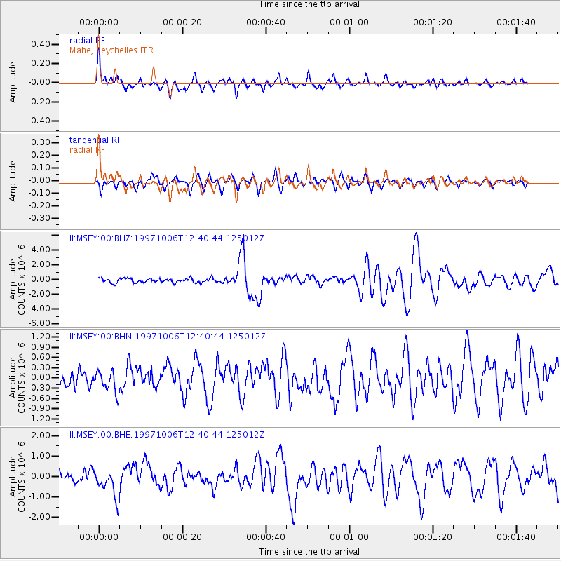
MSEY Mahe, Seychelles - Earthquake Result Viewer

| Earthquake location: |
Mindanao, Philippines |
| Earthquake latitude/longitude: |
9.8/125.8 |
| Earthquake time(UTC): |
1997/10/06 (279) 12:30:05 GMT |
| Earthquake Depth: |
106 km |
| Earthquake Magnitude: |
5.9 MB, 6.5 UNKNOWN, 6.4 MW |
| Earthquake Catalog/Contributor: |
WHDF/NEIC |
|
| Network: |
II Global Seismograph Network (GSN - IRIS/IDA) |
| Station: |
MSEY Mahe, Seychelles |
| Lat/Lon: |
4.67 S/55.48 E |
| Elevation: |
475 m |
|
| Distance: |
71.5 deg |
| Az: |
261.721 deg |
| Baz: |
78.116 deg |
| Ray Param: |
0.05402911 |
| Estimated Moho Depth: |
29.0 km |
| Estimated Crust Vp/Vs: |
1.91 |
| Assumed Crust Vp: |
6.303 km/s |
| Estimated Crust Vs: |
3.3 km/s |
| Estimated Crust Poisson's Ratio: |
0.31 |
|
| Radial Match: |
84.59653 % |
| Radial Bump: |
400 |
| Transverse Match: |
77.75899 % |
| Transverse Bump: |
400 |
| SOD ConfigId: |
6273 |
| Insert Time: |
2010-03-02 00:40:32.531 +0000 |
| GWidth: |
2.5 |
| Max Bumps: |
400 |
| Tol: |
0.001 |
|
Signal To Noise
| Channel | StoN | STA | LTA |
| II:MSEY:00:BHN:19971006T12:40:44.125012Z | 1.2319613 | 3.1236408E-7 | 2.5355024E-7 |
| II:MSEY:00:BHE:19971006T12:40:44.125012Z | 2.6716406 | 7.100199E-7 | 2.6576177E-7 |
| II:MSEY:00:BHZ:19971006T12:40:44.125012Z | 8.372636 | 2.348752E-6 | 2.8052722E-7 |
| Arrivals |
| Ps | 4.3 SECOND |
| PpPs | 13 SECOND |
| PsPs/PpSs | 17 SECOND |


