You are here: Home > Network List > II - Global Seismograph Network (GSN - IRIS/IDA) Stations List
> Station MSEY Mahe, Seychelles > Earthquake Result Viewer
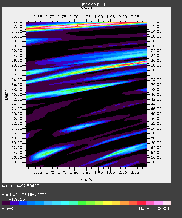
MSEY Mahe, Seychelles - Earthquake Result Viewer
| Earthquake location: |
Mindanao, Philippines |
| Earthquake latitude/longitude: |
5.4/126.8 |
| Earthquake time(UTC): |
1998/09/02 (245) 08:37:29 GMT |
| Earthquake Depth: |
50 km |
| Earthquake Magnitude: |
6.6 MB, 6.7 MS, 6.8 UNKNOWN, 6.8 ME |
| Earthquake Catalog/Contributor: |
WHDF/NEIC |
|
| Network: |
II Global Seismograph Network (GSN - IRIS/IDA) |
| Station: |
MSEY Mahe, Seychelles |
| Lat/Lon: |
4.67 S/55.48 E |
| Elevation: |
475 m |
|
| Distance: |
71.9 deg |
| Az: |
263.322 deg |
| Baz: |
82.795 deg |
| Ray Param: |
0.053927477 |
| Estimated Moho Depth: |
11.25 km |
| Estimated Crust Vp/Vs: |
1.81 |
| Assumed Crust Vp: |
6.303 km/s |
| Estimated Crust Vs: |
3.477 km/s |
| Estimated Crust Poisson's Ratio: |
0.28 |
|
| Radial Match: |
92.58489 % |
| Radial Bump: |
398 |
| Transverse Match: |
81.28259 % |
| Transverse Bump: |
400 |
| SOD ConfigId: |
4480 |
| Insert Time: |
2010-03-02 00:40:36.006 +0000 |
| GWidth: |
2.5 |
| Max Bumps: |
400 |
| Tol: |
0.001 |
|

Signal To Noise
| Channel | StoN | STA | LTA |
| II:MSEY:00:BHN:19980902T08:48:16.860022Z | 16.956656 | 5.8859005E-6 | 3.4711448E-7 |
| II:MSEY:00:BHE:19980902T08:48:16.860022Z | 1.3507495 | 3.5098637E-7 | 2.5984565E-7 |
| II:MSEY:00:BHZ:19980902T08:48:16.860022Z | 8.906408 | 2.062088E-6 | 2.315286E-7 |
| Arrivals |
| Ps | 1.5 SECOND |
| PpPs | 4.9 SECOND |
| PsPs/PpSs | 6.4 SECOND |


