You are here: Home > Network List > II - Global Seismograph Network (GSN - IRIS/IDA) Stations List
> Station MSEY Mahe, Seychelles > Earthquake Result Viewer
MSEY Mahe, Seychelles - Earthquake Result Viewer
| Earthquake location: |
Banda Sea |
| Earthquake latitude/longitude: |
-7.0/129.0 |
| Earthquake time(UTC): |
1998/11/09 (313) 05:30:14 GMT |
| Earthquake Depth: |
33 km |
| Earthquake Magnitude: |
6.1 MB, 6.7 UNKNOWN, 6.6 ME |
| Earthquake Catalog/Contributor: |
WHDF/NEIC |
|
| Network: |
II Global Seismograph Network (GSN - IRIS/IDA) |
| Station: |
MSEY Mahe, Seychelles |
| Lat/Lon: |
4.67 S/55.48 E |
| Elevation: |
475 m |
|
| Distance: |
73.1 deg |
| Az: |
267.222 deg |
| Baz: |
95.824 deg |
| Ray Param: |
0.053153127 |
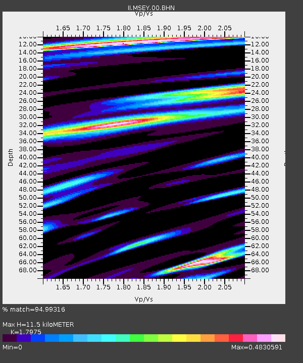
| Estimated Moho Depth: |
11.5 km |
| Estimated Crust Vp/Vs: |
1.80 |
| Assumed Crust Vp: |
6.303 km/s |
| Estimated Crust Vs: |
3.506 km/s |
| Estimated Crust Poisson's Ratio: |
0.28 |
|
| Radial Match: |
94.99316 % |
| Radial Bump: |
400 |
| Transverse Match: |
76.09611 % |
| Transverse Bump: |
400 |
| SOD ConfigId: |
4480 |
| Insert Time: |
2010-03-02 00:40:40.295 +0000 |
| GWidth: |
2.5 |
| Max Bumps: |
400 |
| Tol: |
0.001 |
|

Signal To Noise
| Channel | StoN | STA | LTA |
| II:MSEY:00:BHN:19981109T05:41:10.676001Z | 2.9451175 | 4.2017348E-7 | 1.4266782E-7 |
| II:MSEY:00:BHE:19981109T05:41:10.676001Z | 0.6258773 | 8.5244345E-8 | 1.3619976E-7 |
| II:MSEY:00:BHZ:19981109T05:41:10.676001Z | 1.767946 | 2.4091253E-7 | 1.362669E-7 |
| Arrivals |
| Ps | 1.5 SECOND |
| PpPs | 4.9 SECOND |
| PsPs/PpSs | 6.4 SECOND |


