You are here: Home > Network List > AK - Alaska Regional Network Stations List
> Station BAGL Bagley Icefield, AK, USA > Earthquake Result Viewer
BAGL Bagley Icefield, AK, USA - Earthquake Result Viewer
| Earthquake location: |
Yunnan, China |
| Earthquake latitude/longitude: |
27.2/103.4 |
| Earthquake time(UTC): |
2014/08/03 (215) 08:30:13 GMT |
| Earthquake Depth: |
10 km |
| Earthquake Magnitude: |
6.1 MWB |
| Earthquake Catalog/Contributor: |
NEIC PDE/NEIC COMCAT |
|
| Network: |
AK Alaska Regional Network |
| Station: |
BAGL Bagley Icefield, AK, USA |
| Lat/Lon: |
60.49 N/142.09 W |
| Elevation: |
1470 m |
|
| Distance: |
77.7 deg |
| Az: |
27.462 deg |
| Baz: |
303.974 deg |
| Ray Param: |
0.050142147 |
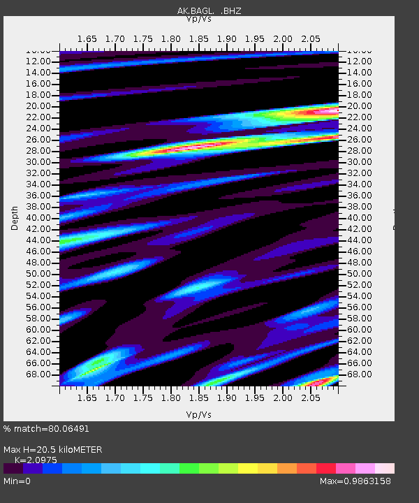
| Estimated Moho Depth: |
20.5 km |
| Estimated Crust Vp/Vs: |
2.10 |
| Assumed Crust Vp: |
6.566 km/s |
| Estimated Crust Vs: |
3.13 km/s |
| Estimated Crust Poisson's Ratio: |
0.35 |
|
| Radial Match: |
80.06491 % |
| Radial Bump: |
400 |
| Transverse Match: |
86.19695 % |
| Transverse Bump: |
400 |
| SOD ConfigId: |
769524 |
| Insert Time: |
2014-08-17 08:51:10.774 +0000 |
| GWidth: |
2.5 |
| Max Bumps: |
400 |
| Tol: |
0.001 |
|

Signal To Noise
| Channel | StoN | STA | LTA |
| AK:BAGL: :BHZ:20140803T08:41:38.987998Z | 3.5528214 | 2.2088022E-7 | 6.217037E-8 |
| AK:BAGL: :BHN:20140803T08:41:38.987998Z | 1.4718517 | 1.17334906E-7 | 7.971924E-8 |
| AK:BAGL: :BHE:20140803T08:41:38.987998Z | 1.030036 | 6.694201E-8 | 6.498997E-8 |
| Arrivals |
| Ps | 3.5 SECOND |
| PpPs | 9.4 SECOND |
| PsPs/PpSs | 13 SECOND |


