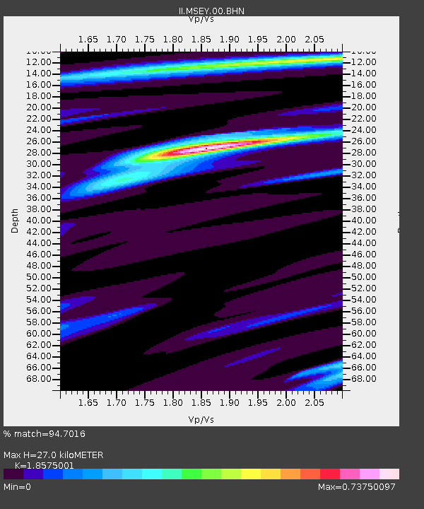
MSEY Mahe, Seychelles - Earthquake Result Viewer
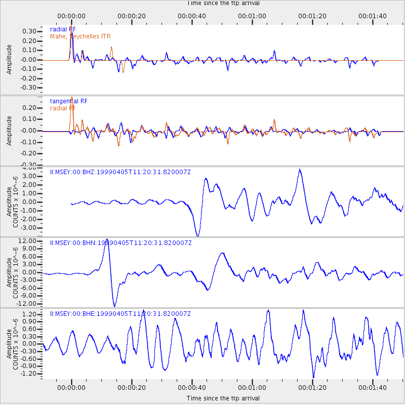
Earthquake location: New Britain Region, P.N.G.
Earthquake latitude/longitude: -5.6/149.6
Earthquake time(UTC): 1999/04/05 (095) 11:08:04 GMT
Earthquake Depth: 150 km
Earthquake Magnitude: 6.2 MB, 7.0 MS, 7.4 MW, 7.3 ME
Earthquake Catalog/Contributor: WHDF/NEIC
Network: II Global Seismograph Network (GSN - IRIS/IDA)
Station: MSEY Mahe, Seychelles
Lat/Lon: 4.67 S/55.48 E
Elevation: 475 m
Distance: 93.6 deg
Az: 264.974 deg
Baz: 95.878 deg
Ray Param: 0.041136056
Estimated Moho Depth: 27.0 km
Estimated Crust Vp/Vs: 1.86
Assumed Crust Vp: 6.303 km/s
Estimated Crust Vs: 3.393 km/s
Estimated Crust Poisson's Ratio: 0.30
Radial Match: 94.7016 %
Radial Bump: 348
Transverse Match: 85.0187 %
Transverse Bump: 386
SOD ConfigId: 4480
Insert Time: 2010-03-02 00:40:51.316 +0000
GWidth: 2.5
Max Bumps: 400
Tol: 0.001

Signal To Noise

ChannelStoNSTALTA
II:MSEY:00:BHN:19990405T11:20:31.820007Z1.36943612.1010904E-71.534274E-7
II:MSEY:00:BHE:19990405T11:20:31.820007Z2.09840463.4686033E-71.6529715E-7
II:MSEY:00:BHZ:19990405T11:20:31.820007Z1.34142142.0876766E-71.5563168E-7
Arrivals
Ps3.7 SECOND
PpPs12 SECOND
PsPs/PpSs16 SECOND