You are here: Home > Network List > II - Global Seismograph Network (GSN - IRIS/IDA) Stations List
> Station MSEY Mahe, Seychelles > Earthquake Result Viewer
MSEY Mahe, Seychelles - Earthquake Result Viewer
| Earthquake location: |
Irian Jaya, Indonesia |
| Earthquake latitude/longitude: |
-2.6/138.2 |
| Earthquake time(UTC): |
1999/05/16 (136) 15:25:53 GMT |
| Earthquake Depth: |
59 km |
| Earthquake Magnitude: |
6.1 MB, 6.2 MS, 6.4 MW, 6.4 ME |
| Earthquake Catalog/Contributor: |
WHDF/NEIC |
|
| Network: |
II Global Seismograph Network (GSN - IRIS/IDA) |
| Station: |
MSEY Mahe, Seychelles |
| Lat/Lon: |
4.67 S/55.48 E |
| Elevation: |
475 m |
|
| Distance: |
82.6 deg |
| Az: |
265.657 deg |
| Baz: |
92.047 deg |
| Ray Param: |
0.046695814 |
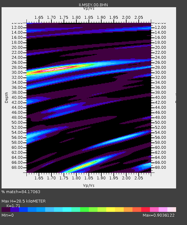
| Estimated Moho Depth: |
28.5 km |
| Estimated Crust Vp/Vs: |
1.71 |
| Assumed Crust Vp: |
6.303 km/s |
| Estimated Crust Vs: |
3.686 km/s |
| Estimated Crust Poisson's Ratio: |
0.24 |
|
| Radial Match: |
84.17063 % |
| Radial Bump: |
400 |
| Transverse Match: |
60.22581 % |
| Transverse Bump: |
400 |
| SOD ConfigId: |
4480 |
| Insert Time: |
2010-03-02 00:40:56.713 +0000 |
| GWidth: |
2.5 |
| Max Bumps: |
400 |
| Tol: |
0.001 |
|

Signal To Noise
| Channel | StoN | STA | LTA |
| II:MSEY:00:BHN:19990516T15:37:39.221011Z | 4.926303 | 9.22802E-7 | 1.8732142E-7 |
| II:MSEY:00:BHE:19990516T15:37:39.221011Z | 0.90848184 | 2.5250458E-7 | 2.7794124E-7 |
| II:MSEY:00:BHZ:19990516T15:37:39.221011Z | 1.9172536 | 2.8885347E-7 | 1.5066003E-7 |
| Arrivals |
| Ps | 3.3 SECOND |
| PpPs | 12 SECOND |
| PsPs/PpSs | 15 SECOND |


