You are here: Home > Network List > TA - USArray Transportable Network (new EarthScope stations) Stations List
> Station TCOL CIGO, UAF Yankovich Road, Fairbanks, AK, USA > Earthquake Result Viewer
TCOL CIGO, UAF Yankovich Road, Fairbanks, AK, USA - Earthquake Result Viewer
| Earthquake location: |
Yunnan, China |
| Earthquake latitude/longitude: |
27.2/103.4 |
| Earthquake time(UTC): |
2014/08/03 (215) 08:30:13 GMT |
| Earthquake Depth: |
10 km |
| Earthquake Magnitude: |
6.1 MWB |
| Earthquake Catalog/Contributor: |
NEIC PDE/NEIC COMCAT |
|
| Network: |
TA USArray Transportable Network (new EarthScope stations) |
| Station: |
TCOL CIGO, UAF Yankovich Road, Fairbanks, AK, USA |
| Lat/Lon: |
64.87 N/147.86 W |
| Elevation: |
178 m |
|
| Distance: |
73.2 deg |
| Az: |
24.994 deg |
| Baz: |
298.229 deg |
| Ray Param: |
0.05319188 |
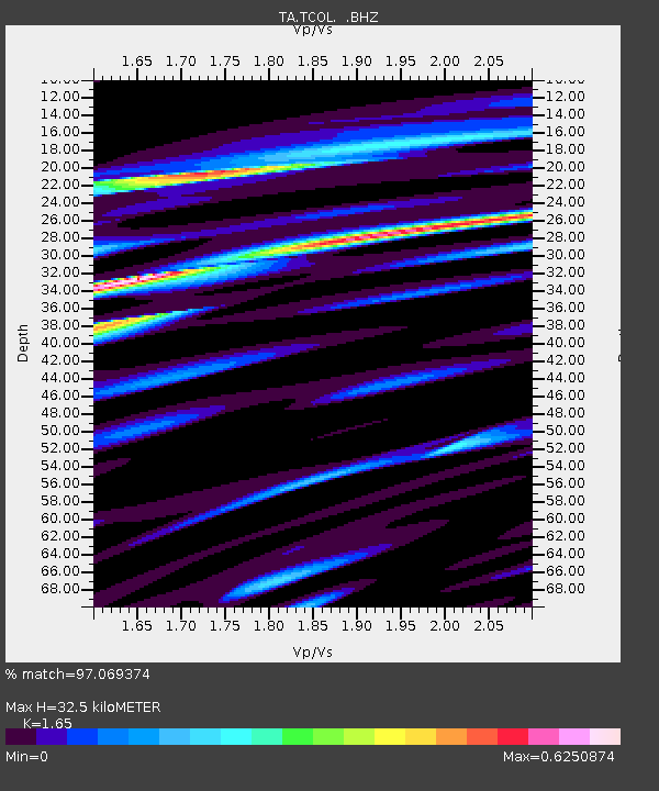
| Estimated Moho Depth: |
32.5 km |
| Estimated Crust Vp/Vs: |
1.65 |
| Assumed Crust Vp: |
6.566 km/s |
| Estimated Crust Vs: |
3.98 km/s |
| Estimated Crust Poisson's Ratio: |
0.21 |
|
| Radial Match: |
97.069374 % |
| Radial Bump: |
338 |
| Transverse Match: |
92.41347 % |
| Transverse Bump: |
400 |
| SOD ConfigId: |
769524 |
| Insert Time: |
2014-08-17 09:10:32.920 +0000 |
| GWidth: |
2.5 |
| Max Bumps: |
400 |
| Tol: |
0.001 |
|

Signal To Noise
| Channel | StoN | STA | LTA |
| TA:TCOL: :BHZ:20140803T08:41:12.92501Z | 7.845944 | 3.6449148E-7 | 4.6456037E-8 |
| TA:TCOL: :BHN:20140803T08:41:12.92501Z | 3.9465187 | 1.845912E-7 | 4.6773174E-8 |
| TA:TCOL: :BHE:20140803T08:41:12.92501Z | 3.3922954 | 1.3860968E-7 | 4.0860144E-8 |
| Arrivals |
| Ps | 3.3 SECOND |
| PpPs | 13 SECOND |
| PsPs/PpSs | 16 SECOND |


