You are here: Home > Network List > TA - USArray Transportable Network (new EarthScope stations) Stations List
> Station MSTX Muleshoe, TX, USA > Earthquake Result Viewer
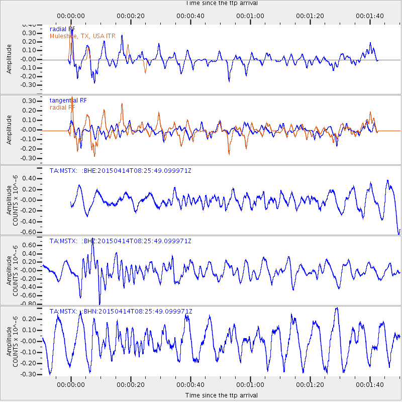
MSTX Muleshoe, TX, USA - Earthquake Result Viewer
*The percent match for this event was below the threshold and hence no stack was calculated.
| Earthquake location: |
Tonga Islands |
| Earthquake latitude/longitude: |
-15.3/-173.2 |
| Earthquake time(UTC): |
2015/04/14 (104) 08:13:57 GMT |
| Earthquake Depth: |
25 km |
| Earthquake Magnitude: |
5.7 MW, 5.3 mb, 5.4 MS |
| Earthquake Catalog/Contributor: |
ISC/ISC |
|
| Network: |
TA USArray Transportable Network (new EarthScope stations) |
| Station: |
MSTX Muleshoe, TX, USA |
| Lat/Lon: |
33.97 N/102.77 W |
| Elevation: |
1167 m |
|
| Distance: |
82.9 deg |
| Az: |
52.101 deg |
| Baz: |
246.408 deg |
| Ray Param: |
$rayparam |
*The percent match for this event was below the threshold and hence was not used in the summary stack. |
|
| Radial Match: |
76.22686 % |
| Radial Bump: |
392 |
| Transverse Match: |
45.39235 % |
| Transverse Bump: |
288 |
| SOD ConfigId: |
7422571 |
| Insert Time: |
2019-04-18 04:37:17.674 +0000 |
| GWidth: |
2.5 |
| Max Bumps: |
400 |
| Tol: |
0.001 |
|
Signal To Noise
| Channel | StoN | STA | LTA |
| TA:MSTX: :BHZ:20150414T08:25:49.099971Z | 2.9094 | 2.4179045E-7 | 8.3106634E-8 |
| TA:MSTX: :BHN:20150414T08:25:49.099971Z | 1.8314794 | 1.643652E-7 | 8.9744496E-8 |
| TA:MSTX: :BHE:20150414T08:25:49.099971Z | 0.8324004 | 9.9527284E-8 | 1.1956661E-7 |
| Arrivals |
| Ps | |
| PpPs | |
| PsPs/PpSs | |


