You are here: Home > Network List > AT - Alaska Tsunami Warning Seismic System Stations List
> Station AKUT Akutan, Alaska > Earthquake Result Viewer
AKUT Akutan, Alaska - Earthquake Result Viewer
| Earthquake location: |
Banda Sea |
| Earthquake latitude/longitude: |
-7.3/128.0 |
| Earthquake time(UTC): |
2014/08/06 (218) 11:45:22 GMT |
| Earthquake Depth: |
10 km |
| Earthquake Magnitude: |
6.1 MWP |
| Earthquake Catalog/Contributor: |
NEIC PDE/NEIC COMCAT |
|
| Network: |
AT Alaska Tsunami Warning Seismic System |
| Station: |
AKUT Akutan, Alaska |
| Lat/Lon: |
54.14 N/165.77 W |
| Elevation: |
19 m |
|
| Distance: |
82.3 deg |
| Az: |
32.905 deg |
| Baz: |
246.326 deg |
| Ray Param: |
0.046986375 |
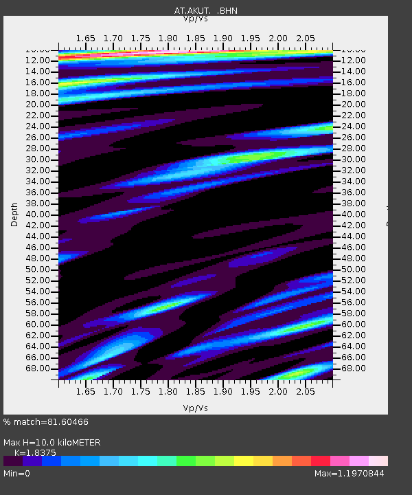
| Estimated Moho Depth: |
10.0 km |
| Estimated Crust Vp/Vs: |
1.84 |
| Assumed Crust Vp: |
5.989 km/s |
| Estimated Crust Vs: |
3.259 km/s |
| Estimated Crust Poisson's Ratio: |
0.29 |
|
| Radial Match: |
81.60466 % |
| Radial Bump: |
400 |
| Transverse Match: |
73.62527 % |
| Transverse Bump: |
400 |
| SOD ConfigId: |
769524 |
| Insert Time: |
2014-08-20 11:53:49.340 +0000 |
| GWidth: |
2.5 |
| Max Bumps: |
400 |
| Tol: |
0.001 |
|

Signal To Noise
| Channel | StoN | STA | LTA |
| AT:AKUT: :BHZ:20140806T11:57:13.139993Z | 3.5405471 | 8.103254E-7 | 2.2887009E-7 |
| AT:AKUT: :BHN:20140806T11:57:13.139993Z | 1.4361302 | 1.6964911E-7 | 1.1812934E-7 |
| AT:AKUT: :BHE:20140806T11:57:13.139993Z | 2.3042095 | 2.6735316E-7 | 1.1602815E-7 |
| Arrivals |
| Ps | 1.4 SECOND |
| PpPs | 4.6 SECOND |
| PsPs/PpSs | 6.1 SECOND |


