You are here: Home > Network List > II - Global Seismograph Network (GSN - IRIS/IDA) Stations List
> Station MSEY Mahe, Seychelles > Earthquake Result Viewer
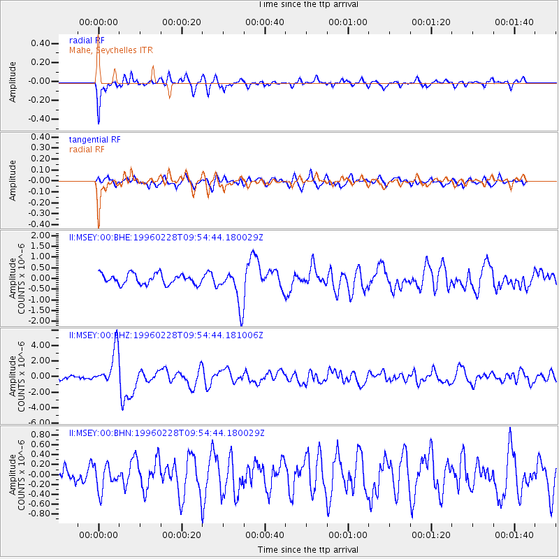
MSEY Mahe, Seychelles - Earthquake Result Viewer
*The percent match for this event was below the threshold and hence no stack was calculated.
| Earthquake location: |
Northern Molucca Sea |
| Earthquake latitude/longitude: |
1.7/126.1 |
| Earthquake time(UTC): |
1996/02/28 (059) 09:44:09 GMT |
| Earthquake Depth: |
103 km |
| Earthquake Magnitude: |
6.1 MB, 6.4 UNKNOWN, 6.4 MW |
| Earthquake Catalog/Contributor: |
WHDF/NEIC |
|
| Network: |
II Global Seismograph Network (GSN - IRIS/IDA) |
| Station: |
MSEY Mahe, Seychelles |
| Lat/Lon: |
4.67 S/55.48 E |
| Elevation: |
475 m |
|
| Distance: |
70.8 deg |
| Az: |
264.482 deg |
| Baz: |
86.556 deg |
| Ray Param: |
$rayparam |
*The percent match for this event was below the threshold and hence was not used in the summary stack. |
|
| Radial Match: |
82.988014 % |
| Radial Bump: |
398 |
| Transverse Match: |
68.85148 % |
| Transverse Bump: |
400 |
| SOD ConfigId: |
4480 |
| Insert Time: |
2010-03-02 00:41:42.831 +0000 |
| GWidth: |
2.5 |
| Max Bumps: |
400 |
| Tol: |
0.001 |
|
Signal To Noise
| Channel | StoN | STA | LTA |
| II:MSEY:00:BHZ:19960228T09:54:44.181006Z | 11.455764 | 2.452852E-6 | 2.141151E-7 |
| II:MSEY:00:BHN:19960228T09:54:44.180029Z | 1.3955652 | 2.5349217E-7 | 1.8164124E-7 |
| II:MSEY:00:BHE:19960228T09:54:44.180029Z | 3.750323 | 9.0106266E-7 | 2.4026266E-7 |
| Arrivals |
| Ps | |
| PpPs | |
| PsPs/PpSs | |


