You are here: Home > Network List > IM - International Miscellaneous Stations Stations List
> Station MK31 Makanchi Array Site 31, Kazakhstan > Earthquake Result Viewer
MK31 Makanchi Array Site 31, Kazakhstan - Earthquake Result Viewer
| Earthquake location: |
Banda Sea |
| Earthquake latitude/longitude: |
-7.3/128.0 |
| Earthquake time(UTC): |
2014/08/06 (218) 11:45:22 GMT |
| Earthquake Depth: |
10 km |
| Earthquake Magnitude: |
6.1 MWP |
| Earthquake Catalog/Contributor: |
NEIC PDE/NEIC COMCAT |
|
| Network: |
IM International Miscellaneous Stations |
| Station: |
MK31 Makanchi Array Site 31, Kazakhstan |
| Lat/Lon: |
46.79 N/82.29 E |
| Elevation: |
618 m |
|
| Distance: |
67.4 deg |
| Az: |
327.784 deg |
| Baz: |
129.668 deg |
| Ray Param: |
0.056977615 |
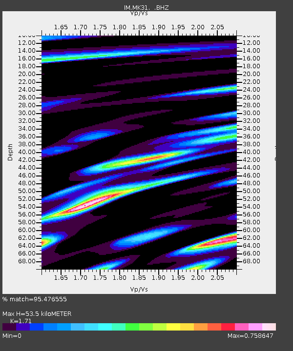
| Estimated Moho Depth: |
53.5 km |
| Estimated Crust Vp/Vs: |
1.71 |
| Assumed Crust Vp: |
6.688 km/s |
| Estimated Crust Vs: |
3.911 km/s |
| Estimated Crust Poisson's Ratio: |
0.24 |
|
| Radial Match: |
95.476555 % |
| Radial Bump: |
400 |
| Transverse Match: |
93.04389 % |
| Transverse Bump: |
400 |
| SOD ConfigId: |
769524 |
| Insert Time: |
2014-08-20 11:58:28.590 +0000 |
| GWidth: |
2.5 |
| Max Bumps: |
400 |
| Tol: |
0.001 |
|

Signal To Noise
| Channel | StoN | STA | LTA |
| IM:MK31: :BHZ:20140806T11:55:47.274026Z | 45.366726 | 7.1603736E-8 | 1.5783316E-9 |
| IM:MK31: :BHN:20140806T11:55:47.274026Z | 14.998978 | 2.2097188E-8 | 1.4732463E-9 |
| IM:MK31: :BHE:20140806T11:55:47.274026Z | 23.339779 | 3.0759267E-8 | 1.3178902E-9 |
| Arrivals |
| Ps | 5.9 SECOND |
| PpPs | 21 SECOND |
| PsPs/PpSs | 27 SECOND |


