You are here: Home > Network List > UW - Pacific Northwest Regional Seismic Network Stations List
> Station PASS Maple Falls, WA, USA > Earthquake Result Viewer
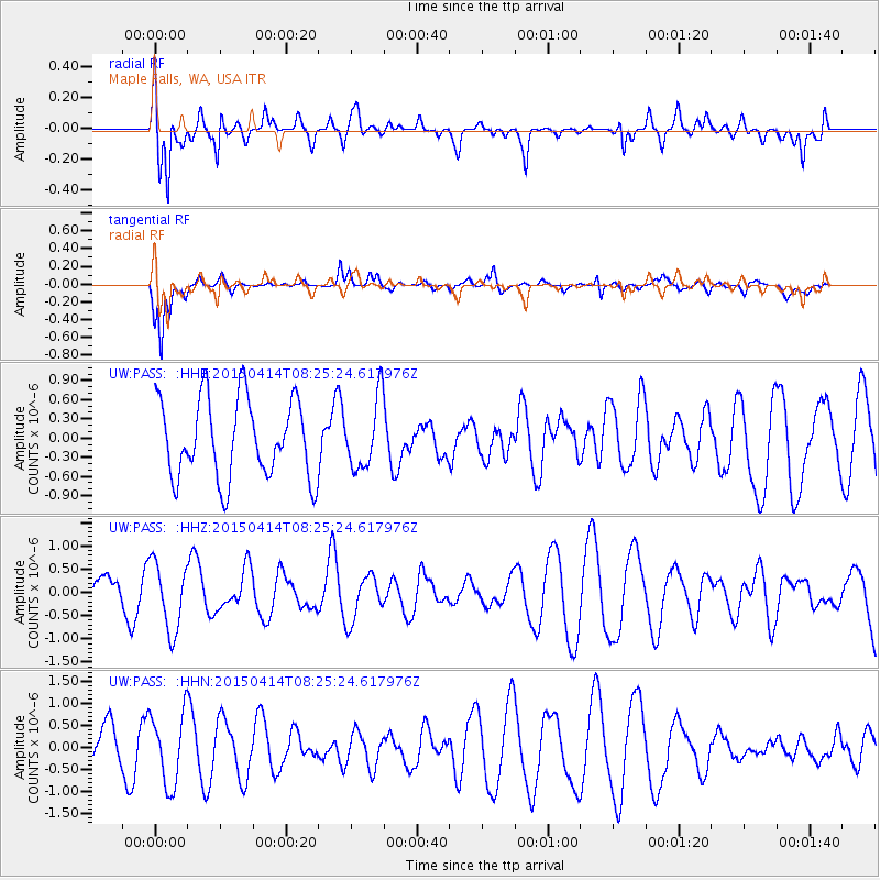
PASS Maple Falls, WA, USA - Earthquake Result Viewer
*The percent match for this event was below the threshold and hence no stack was calculated.
| Earthquake location: |
Tonga Islands |
| Earthquake latitude/longitude: |
-15.3/-173.2 |
| Earthquake time(UTC): |
2015/04/14 (104) 08:13:57 GMT |
| Earthquake Depth: |
25 km |
| Earthquake Magnitude: |
5.7 MW, 5.3 mb, 5.4 MS |
| Earthquake Catalog/Contributor: |
ISC/ISC |
|
| Network: |
UW Pacific Northwest Regional Seismic Network |
| Station: |
PASS Maple Falls, WA, USA |
| Lat/Lon: |
49.00 N/122.09 W |
| Elevation: |
174 m |
|
| Distance: |
78.3 deg |
| Az: |
31.568 deg |
| Baz: |
230.104 deg |
| Ray Param: |
$rayparam |
*The percent match for this event was below the threshold and hence was not used in the summary stack. |
|
| Radial Match: |
58.154903 % |
| Radial Bump: |
400 |
| Transverse Match: |
63.59082 % |
| Transverse Bump: |
400 |
| SOD ConfigId: |
7422571 |
| Insert Time: |
2019-04-18 04:38:19.909 +0000 |
| GWidth: |
2.5 |
| Max Bumps: |
400 |
| Tol: |
0.001 |
|
Signal To Noise
| Channel | StoN | STA | LTA |
| UW:PASS: :HHZ:20150414T08:25:24.617976Z | 1.4722677 | 7.3621396E-7 | 5.000544E-7 |
| UW:PASS: :HHN:20150414T08:25:24.617976Z | 2.1192515 | 8.07144E-7 | 3.8086276E-7 |
| UW:PASS: :HHE:20150414T08:25:24.617976Z | 0.8763743 | 5.446259E-7 | 6.214535E-7 |
| Arrivals |
| Ps | |
| PpPs | |
| PsPs/PpSs | |


