You are here: Home > Network List > TJ - Tajikistan National Seismic Network Stations List
> Station GARM Garm, Tajikistan > Earthquake Result Viewer
GARM Garm, Tajikistan - Earthquake Result Viewer

| Earthquake location: |
Banda Sea |
| Earthquake latitude/longitude: |
-7.3/128.0 |
| Earthquake time(UTC): |
2014/08/06 (218) 11:45:22 GMT |
| Earthquake Depth: |
10 km |
| Earthquake Magnitude: |
6.1 MWP |
| Earthquake Catalog/Contributor: |
NEIC PDE/NEIC COMCAT |
|
| Network: |
TJ Tajikistan National Seismic Network |
| Station: |
GARM Garm, Tajikistan |
| Lat/Lon: |
39.00 N/70.32 E |
| Elevation: |
1305 m |
|
| Distance: |
70.5 deg |
| Az: |
315.656 deg |
| Baz: |
117.139 deg |
| Ray Param: |
0.05494599 |
| Estimated Moho Depth: |
21.75 km |
| Estimated Crust Vp/Vs: |
1.80 |
| Assumed Crust Vp: |
6.306 km/s |
| Estimated Crust Vs: |
3.498 km/s |
| Estimated Crust Poisson's Ratio: |
0.28 |
|
| Radial Match: |
83.810295 % |
| Radial Bump: |
400 |
| Transverse Match: |
90.36721 % |
| Transverse Bump: |
400 |
| SOD ConfigId: |
769524 |
| Insert Time: |
2014-08-20 12:04:09.274 +0000 |
| GWidth: |
2.5 |
| Max Bumps: |
400 |
| Tol: |
0.001 |
|
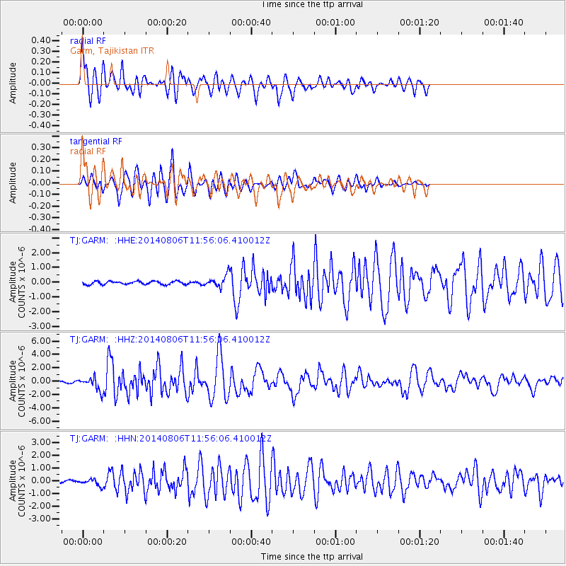
Signal To Noise
| Channel | StoN | STA | LTA |
| TJ:GARM: :HHZ:20140806T11:56:06.410012Z | 6.306888 | 1.0152943E-6 | 1.6098181E-7 |
| TJ:GARM: :HHN:20140806T11:56:06.410012Z | 2.1872072 | 2.6555028E-7 | 1.2141066E-7 |
| TJ:GARM: :HHE:20140806T11:56:06.410012Z | 3.7562149 | 4.063633E-7 | 1.0818426E-7 |
| Arrivals |
| Ps | 2.9 SECOND |
| PpPs | 9.3 SECOND |
| PsPs/PpSs | 12 SECOND |


