You are here: Home > Network List > CI - Caltech Regional Seismic Network Stations List
> Station MPP McPhearson Peak > Earthquake Result Viewer
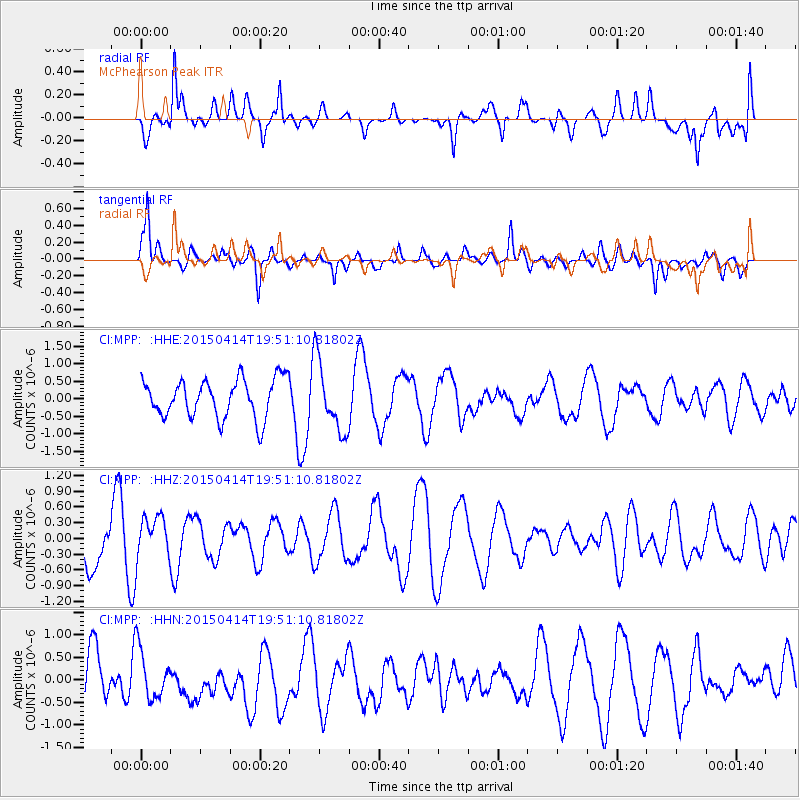
MPP McPhearson Peak - Earthquake Result Viewer
*The percent match for this event was below the threshold and hence no stack was calculated.
| Earthquake location: |
Kuril Islands |
| Earthquake latitude/longitude: |
48.0/152.7 |
| Earthquake time(UTC): |
2015/04/14 (104) 19:41:27 GMT |
| Earthquake Depth: |
147 km |
| Earthquake Magnitude: |
4.6 mb, 4.5 mb |
| Earthquake Catalog/Contributor: |
ISC/ISC |
|
| Network: |
CI Caltech Regional Seismic Network |
| Station: |
MPP McPhearson Peak |
| Lat/Lon: |
34.89 N/119.81 W |
| Elevation: |
1739 m |
|
| Distance: |
63.5 deg |
| Az: |
66.596 deg |
| Baz: |
311.41 deg |
| Ray Param: |
$rayparam |
*The percent match for this event was below the threshold and hence was not used in the summary stack. |
|
| Radial Match: |
64.935524 % |
| Radial Bump: |
400 |
| Transverse Match: |
74.18118 % |
| Transverse Bump: |
400 |
| SOD ConfigId: |
7422571 |
| Insert Time: |
2019-04-18 04:40:42.290 +0000 |
| GWidth: |
2.5 |
| Max Bumps: |
400 |
| Tol: |
0.001 |
|
Signal To Noise
| Channel | StoN | STA | LTA |
| CI:MPP: :HHZ:20150414T19:51:10.81802Z | 0.82657486 | 4.1298964E-7 | 4.996397E-7 |
| CI:MPP: :HHN:20150414T19:51:10.81802Z | 1.0851691 | 5.483301E-7 | 5.052946E-7 |
| CI:MPP: :HHE:20150414T19:51:10.81802Z | 1.8276876 | 1.0056636E-6 | 5.5023827E-7 |
| Arrivals |
| Ps | |
| PpPs | |
| PsPs/PpSs | |


