You are here: Home > Network List > AK - Alaska Regional Network Stations List
> Station CUT Chulitna, AK, USA > Earthquake Result Viewer
CUT Chulitna, AK, USA - Earthquake Result Viewer

| Earthquake location: |
Hokkaido, Japan Region |
| Earthquake latitude/longitude: |
41.1/142.2 |
| Earthquake time(UTC): |
2014/08/10 (222) 03:43:16 GMT |
| Earthquake Depth: |
38 km |
| Earthquake Magnitude: |
6.0 MB |
| Earthquake Catalog/Contributor: |
NEIC PDE/NEIC COMCAT |
|
| Network: |
AK Alaska Regional Network |
| Station: |
CUT Chulitna, AK, USA |
| Lat/Lon: |
62.41 N/150.26 W |
| Elevation: |
574 m |
|
| Distance: |
44.4 deg |
| Az: |
37.949 deg |
| Baz: |
274.108 deg |
| Ray Param: |
0.07184692 |
| Estimated Moho Depth: |
63.75 km |
| Estimated Crust Vp/Vs: |
2.05 |
| Assumed Crust Vp: |
6.438 km/s |
| Estimated Crust Vs: |
3.141 km/s |
| Estimated Crust Poisson's Ratio: |
0.34 |
|
| Radial Match: |
80.66556 % |
| Radial Bump: |
400 |
| Transverse Match: |
77.40144 % |
| Transverse Bump: |
400 |
| SOD ConfigId: |
769524 |
| Insert Time: |
2014-08-24 04:03:03.602 +0000 |
| GWidth: |
2.5 |
| Max Bumps: |
400 |
| Tol: |
0.001 |
|
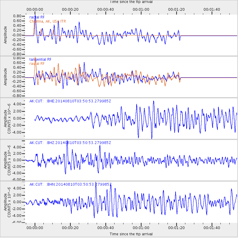
Signal To Noise
| Channel | StoN | STA | LTA |
| AK:CUT: :BHZ:20140810T03:50:53.279985Z | 6.868763 | 1.2077874E-6 | 1.7583768E-7 |
| AK:CUT: :BHN:20140810T03:50:53.279985Z | 1.2558593 | 5.7820654E-7 | 4.6040708E-7 |
| AK:CUT: :BHE:20140810T03:50:53.279985Z | 2.6539671 | 1.1478164E-6 | 4.324908E-7 |
| Arrivals |
| Ps | 11 SECOND |
| PpPs | 29 SECOND |
| PsPs/PpSs | 40 SECOND |


