You are here: Home > Network List > TA - USArray Transportable Network (new EarthScope stations) Stations List
> Station W41B Gary Mavity, Velonia, AR, USA > Earthquake Result Viewer
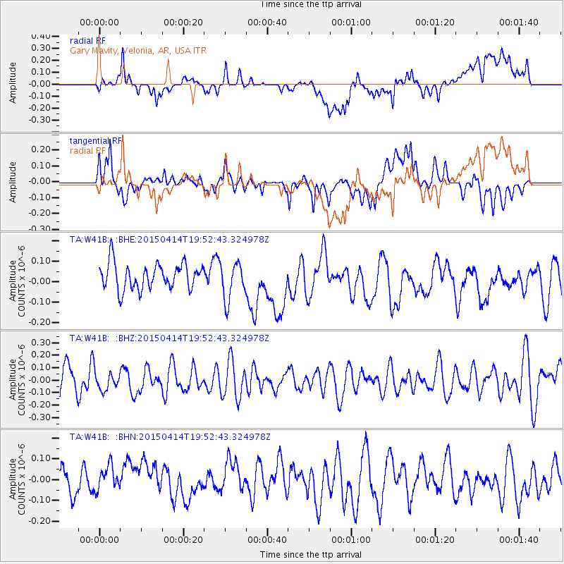
W41B Gary Mavity, Velonia, AR, USA - Earthquake Result Viewer
*The percent match for this event was below the threshold and hence no stack was calculated.
| Earthquake location: |
Kuril Islands |
| Earthquake latitude/longitude: |
48.0/152.7 |
| Earthquake time(UTC): |
2015/04/14 (104) 19:41:27 GMT |
| Earthquake Depth: |
147 km |
| Earthquake Magnitude: |
4.6 mb, 4.5 mb |
| Earthquake Catalog/Contributor: |
ISC/ISC |
|
| Network: |
TA USArray Transportable Network (new EarthScope stations) |
| Station: |
W41B Gary Mavity, Velonia, AR, USA |
| Lat/Lon: |
35.17 N/92.25 W |
| Elevation: |
95 m |
|
| Distance: |
78.9 deg |
| Az: |
49.152 deg |
| Baz: |
321.66 deg |
| Ray Param: |
$rayparam |
*The percent match for this event was below the threshold and hence was not used in the summary stack. |
|
| Radial Match: |
42.679855 % |
| Radial Bump: |
400 |
| Transverse Match: |
52.824112 % |
| Transverse Bump: |
400 |
| SOD ConfigId: |
7422571 |
| Insert Time: |
2019-04-18 04:45:27.808 +0000 |
| GWidth: |
2.5 |
| Max Bumps: |
400 |
| Tol: |
0.001 |
|
Signal To Noise
| Channel | StoN | STA | LTA |
| TA:W41B: :BHZ:20150414T19:52:43.324978Z | 0.47642845 | 6.1334354E-8 | 1.2873781E-7 |
| TA:W41B: :BHN:20150414T19:52:43.324978Z | 1.1004575 | 9.4771565E-8 | 8.612015E-8 |
| TA:W41B: :BHE:20150414T19:52:43.324978Z | 1.469006 | 9.322743E-8 | 6.3462934E-8 |
| Arrivals |
| Ps | |
| PpPs | |
| PsPs/PpSs | |


