You are here: Home > Network List > GS - US Geological Survey Networks Stations List
> Station OK029 Liberty Lake, Oklahoma, USA > Earthquake Result Viewer
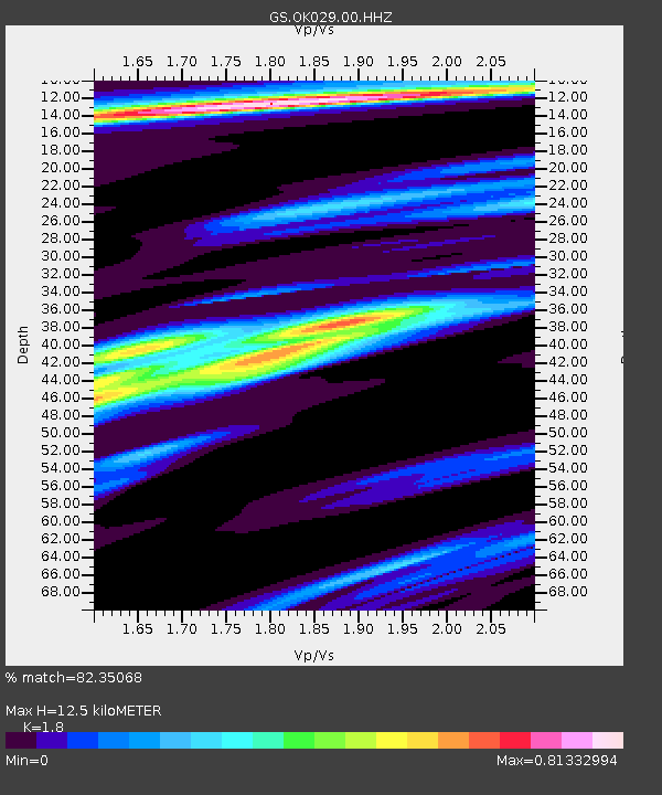
OK029 Liberty Lake, Oklahoma, USA - Earthquake Result Viewer
| Earthquake location: |
Hokkaido, Japan Region |
| Earthquake latitude/longitude: |
41.1/142.2 |
| Earthquake time(UTC): |
2014/08/10 (222) 03:43:16 GMT |
| Earthquake Depth: |
38 km |
| Earthquake Magnitude: |
6.0 MB |
| Earthquake Catalog/Contributor: |
NEIC PDE/NEIC COMCAT |
|
| Network: |
GS US Geological Survey Networks |
| Station: |
OK029 Liberty Lake, Oklahoma, USA |
| Lat/Lon: |
35.80 N/97.45 W |
| Elevation: |
333 m |
|
| Distance: |
85.9 deg |
| Az: |
44.68 deg |
| Baz: |
319.213 deg |
| Ray Param: |
0.04436829 |
| Estimated Moho Depth: |
12.5 km |
| Estimated Crust Vp/Vs: |
1.80 |
| Assumed Crust Vp: |
6.426 km/s |
| Estimated Crust Vs: |
3.57 km/s |
| Estimated Crust Poisson's Ratio: |
0.28 |
|
| Radial Match: |
82.35068 % |
| Radial Bump: |
396 |
| Transverse Match: |
67.16185 % |
| Transverse Bump: |
390 |
| SOD ConfigId: |
769524 |
| Insert Time: |
2014-08-24 04:21:17.064 +0000 |
| GWidth: |
2.5 |
| Max Bumps: |
400 |
| Tol: |
0.001 |
|

Signal To Noise
| Channel | StoN | STA | LTA |
| GS:OK029:00:HHZ:20140810T03:55:21.53499Z | 8.358352 | 9.5309343E-7 | 1.1402888E-7 |
| GS:OK029:00:HH1:20140810T03:55:21.53499Z | 1.7201356 | 2.017206E-7 | 1.1727017E-7 |
| GS:OK029:00:HH2:20140810T03:55:21.53499Z | 1.7483022 | 2.1993486E-7 | 1.257991E-7 |
| Arrivals |
| Ps | 1.6 SECOND |
| PpPs | 5.3 SECOND |
| PsPs/PpSs | 6.9 SECOND |


