You are here: Home > Network List > TA - USArray Transportable Network (new EarthScope stations) Stations List
> Station D46A Sault St. Marie, ON, CAN > Earthquake Result Viewer
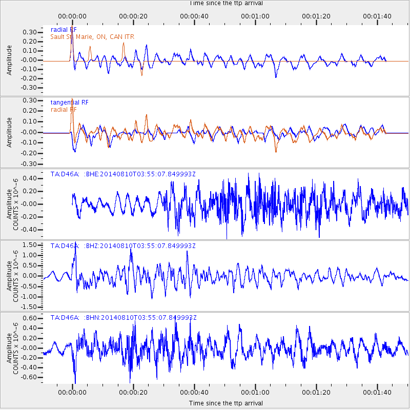
D46A Sault St. Marie, ON, CAN - Earthquake Result Viewer
*The percent match for this event was below the threshold and hence no stack was calculated.
| Earthquake location: |
Hokkaido, Japan Region |
| Earthquake latitude/longitude: |
41.1/142.2 |
| Earthquake time(UTC): |
2014/08/10 (222) 03:43:16 GMT |
| Earthquake Depth: |
38 km |
| Earthquake Magnitude: |
6.0 MB |
| Earthquake Catalog/Contributor: |
NEIC PDE/NEIC COMCAT |
|
| Network: |
TA USArray Transportable Network (new EarthScope stations) |
| Station: |
D46A Sault St. Marie, ON, CAN |
| Lat/Lon: |
46.89 N/84.04 W |
| Elevation: |
353 m |
|
| Distance: |
83.2 deg |
| Az: |
29.905 deg |
| Baz: |
326.698 deg |
| Ray Param: |
$rayparam |
*The percent match for this event was below the threshold and hence was not used in the summary stack. |
|
| Radial Match: |
73.01436 % |
| Radial Bump: |
396 |
| Transverse Match: |
51.427498 % |
| Transverse Bump: |
400 |
| SOD ConfigId: |
769524 |
| Insert Time: |
2014-08-24 04:47:08.189 +0000 |
| GWidth: |
2.5 |
| Max Bumps: |
400 |
| Tol: |
0.001 |
|
Signal To Noise
| Channel | StoN | STA | LTA |
| TA:D46A: :BHZ:20140810T03:55:07.849993Z | 3.3390164 | 5.4004573E-7 | 1.6173796E-7 |
| TA:D46A: :BHN:20140810T03:55:07.849993Z | 2.0868592 | 2.4427266E-7 | 1.1705277E-7 |
| TA:D46A: :BHE:20140810T03:55:07.849993Z | 2.2614882 | 2.10017E-7 | 9.286673E-8 |
| Arrivals |
| Ps | |
| PpPs | |
| PsPs/PpSs | |


