You are here: Home > Network List > TA - USArray Transportable Network (new EarthScope stations) Stations List
> Station F61A St Evariste, QC, CAN > Earthquake Result Viewer
F61A St Evariste, QC, CAN - Earthquake Result Viewer
*The percent match for this event was below the threshold and hence no stack was calculated.
| Earthquake location: |
Hokkaido, Japan Region |
| Earthquake latitude/longitude: |
41.1/142.2 |
| Earthquake time(UTC): |
2014/08/10 (222) 03:43:16 GMT |
| Earthquake Depth: |
38 km |
| Earthquake Magnitude: |
6.0 MB |
| Earthquake Catalog/Contributor: |
NEIC PDE/NEIC COMCAT |
|
| Network: |
TA USArray Transportable Network (new EarthScope stations) |
| Station: |
F61A St Evariste, QC, CAN |
| Lat/Lon: |
45.97 N/70.99 W |
| Elevation: |
350 m |
|
| Distance: |
88.3 deg |
| Az: |
22.435 deg |
| Baz: |
335.587 deg |
| Ray Param: |
$rayparam |
*The percent match for this event was below the threshold and hence was not used in the summary stack. |
|
| Radial Match: |
63.32286 % |
| Radial Bump: |
400 |
| Transverse Match: |
54.440334 % |
| Transverse Bump: |
400 |
| SOD ConfigId: |
769524 |
| Insert Time: |
2014-08-24 04:50:07.406 +0000 |
| GWidth: |
2.5 |
| Max Bumps: |
400 |
| Tol: |
0.001 |
|
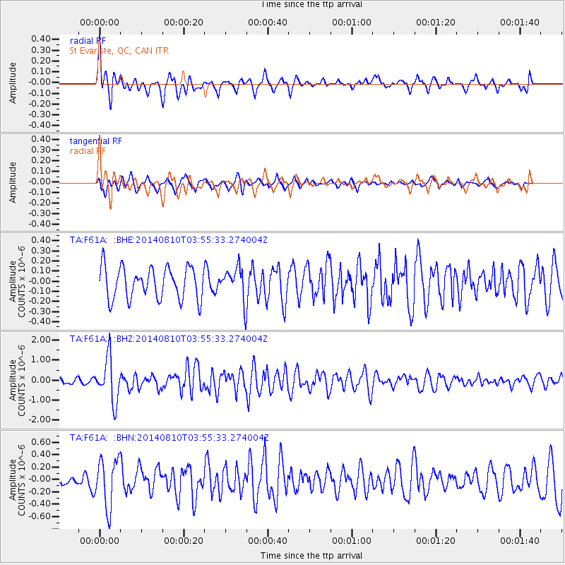
Signal To Noise
| Channel | StoN | STA | LTA |
| TA:F61A: :BHZ:20140810T03:55:33.274004Z | 6.7505965 | 1.1362113E-6 | 1.6831272E-7 |
| TA:F61A: :BHN:20140810T03:55:33.274004Z | 3.6136982 | 4.0159458E-7 | 1.11131186E-7 |
| TA:F61A: :BHE:20140810T03:55:33.274004Z | 1.0631709 | 1.6603617E-7 | 1.5617073E-7 |
| Arrivals |
| Ps | |
| PpPs | |
| PsPs/PpSs | |


