You are here: Home > Network List > TA - USArray Transportable Network (new EarthScope stations) Stations List
> Station I61A Oroboro, Fairlee, VT, USA > Earthquake Result Viewer
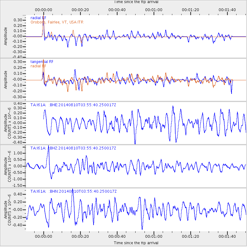
I61A Oroboro, Fairlee, VT, USA - Earthquake Result Viewer
*The percent match for this event was below the threshold and hence no stack was calculated.
| Earthquake location: |
Hokkaido, Japan Region |
| Earthquake latitude/longitude: |
41.1/142.2 |
| Earthquake time(UTC): |
2014/08/10 (222) 03:43:16 GMT |
| Earthquake Depth: |
38 km |
| Earthquake Magnitude: |
6.0 MB |
| Earthquake Catalog/Contributor: |
NEIC PDE/NEIC COMCAT |
|
| Network: |
TA USArray Transportable Network (new EarthScope stations) |
| Station: |
I61A Oroboro, Fairlee, VT, USA |
| Lat/Lon: |
43.93 N/72.21 W |
| Elevation: |
287 m |
|
| Distance: |
89.8 deg |
| Az: |
24.077 deg |
| Baz: |
334.756 deg |
| Ray Param: |
$rayparam |
*The percent match for this event was below the threshold and hence was not used in the summary stack. |
|
| Radial Match: |
69.05749 % |
| Radial Bump: |
390 |
| Transverse Match: |
65.244026 % |
| Transverse Bump: |
400 |
| SOD ConfigId: |
769524 |
| Insert Time: |
2014-08-24 04:52:46.058 +0000 |
| GWidth: |
2.5 |
| Max Bumps: |
400 |
| Tol: |
0.001 |
|
Signal To Noise
| Channel | StoN | STA | LTA |
| TA:I61A: :BHZ:20140810T03:55:40.250017Z | 4.204926 | 6.736903E-7 | 1.6021454E-7 |
| TA:I61A: :BHN:20140810T03:55:40.250017Z | 2.368613 | 2.2680054E-7 | 9.575247E-8 |
| TA:I61A: :BHE:20140810T03:55:40.250017Z | 1.3593965 | 1.5551173E-7 | 1.1439763E-7 |
| Arrivals |
| Ps | |
| PpPs | |
| PsPs/PpSs | |


