You are here: Home > Network List > TA - USArray Transportable Network (new EarthScope stations) Stations List
> Station J04D Umpqua National Forest, Toketee, OR, USA > Earthquake Result Viewer
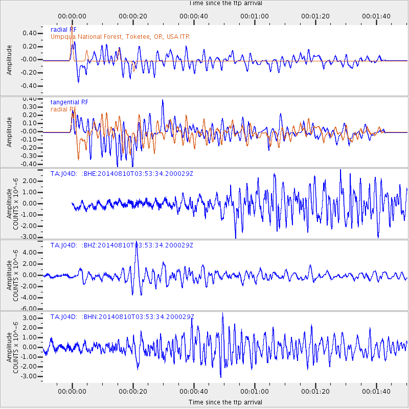
J04D Umpqua National Forest, Toketee, OR, USA - Earthquake Result Viewer
*The percent match for this event was below the threshold and hence no stack was calculated.
| Earthquake location: |
Hokkaido, Japan Region |
| Earthquake latitude/longitude: |
41.1/142.2 |
| Earthquake time(UTC): |
2014/08/10 (222) 03:43:16 GMT |
| Earthquake Depth: |
38 km |
| Earthquake Magnitude: |
6.0 MB |
| Earthquake Catalog/Contributor: |
NEIC PDE/NEIC COMCAT |
|
| Network: |
TA USArray Transportable Network (new EarthScope stations) |
| Station: |
J04D Umpqua National Forest, Toketee, OR, USA |
| Lat/Lon: |
43.24 N/122.11 W |
| Elevation: |
1948 m |
|
| Distance: |
66.9 deg |
| Az: |
52.236 deg |
| Baz: |
305.211 deg |
| Ray Param: |
$rayparam |
*The percent match for this event was below the threshold and hence was not used in the summary stack. |
|
| Radial Match: |
75.26634 % |
| Radial Bump: |
400 |
| Transverse Match: |
82.75826 % |
| Transverse Bump: |
400 |
| SOD ConfigId: |
769524 |
| Insert Time: |
2014-08-24 04:53:04.388 +0000 |
| GWidth: |
2.5 |
| Max Bumps: |
400 |
| Tol: |
0.001 |
|
Signal To Noise
| Channel | StoN | STA | LTA |
| TA:J04D: :BHZ:20140810T03:53:34.200029Z | 4.6002097 | 7.558632E-7 | 1.6431059E-7 |
| TA:J04D: :BHN:20140810T03:53:34.200029Z | 0.9583025 | 3.4041042E-7 | 3.552223E-7 |
| TA:J04D: :BHE:20140810T03:53:34.200029Z | 1.3091162 | 3.222803E-7 | 2.4618157E-7 |
| Arrivals |
| Ps | |
| PpPs | |
| PsPs/PpSs | |


