You are here: Home > Network List > TA - USArray Transportable Network (new EarthScope stations) Stations List
> Station J61A Chester, VT, USA > Earthquake Result Viewer
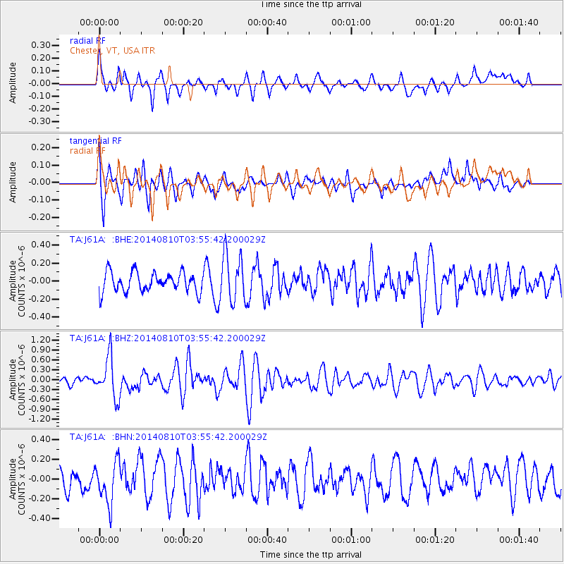
J61A Chester, VT, USA - Earthquake Result Viewer
*The percent match for this event was below the threshold and hence no stack was calculated.
| Earthquake location: |
Hokkaido, Japan Region |
| Earthquake latitude/longitude: |
41.1/142.2 |
| Earthquake time(UTC): |
2014/08/10 (222) 03:43:16 GMT |
| Earthquake Depth: |
38 km |
| Earthquake Magnitude: |
6.0 MB |
| Earthquake Catalog/Contributor: |
NEIC PDE/NEIC COMCAT |
|
| Network: |
TA USArray Transportable Network (new EarthScope stations) |
| Station: |
J61A Chester, VT, USA |
| Lat/Lon: |
43.35 N/72.55 W |
| Elevation: |
253 m |
|
| Distance: |
90.3 deg |
| Az: |
24.554 deg |
| Baz: |
334.518 deg |
| Ray Param: |
$rayparam |
*The percent match for this event was below the threshold and hence was not used in the summary stack. |
|
| Radial Match: |
66.34764 % |
| Radial Bump: |
400 |
| Transverse Match: |
57.980656 % |
| Transverse Bump: |
400 |
| SOD ConfigId: |
769524 |
| Insert Time: |
2014-08-24 04:53:42.804 +0000 |
| GWidth: |
2.5 |
| Max Bumps: |
400 |
| Tol: |
0.001 |
|
Signal To Noise
| Channel | StoN | STA | LTA |
| TA:J61A: :BHZ:20140810T03:55:42.200029Z | 5.6149244 | 6.3538835E-7 | 1.13160624E-7 |
| TA:J61A: :BHN:20140810T03:55:42.200029Z | 2.6470659 | 2.1869302E-7 | 8.261715E-8 |
| TA:J61A: :BHE:20140810T03:55:42.200029Z | 2.4499595 | 2.6517708E-7 | 1.0823733E-7 |
| Arrivals |
| Ps | |
| PpPs | |
| PsPs/PpSs | |


