You are here: Home > Network List > TA - USArray Transportable Network (new EarthScope stations) Stations List
> Station K61A Williamstown, MA, USA > Earthquake Result Viewer
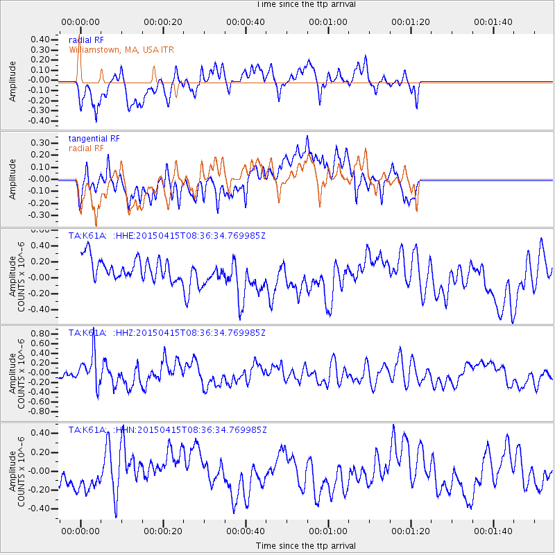
K61A Williamstown, MA, USA - Earthquake Result Viewer
*The percent match for this event was below the threshold and hence no stack was calculated.
| Earthquake location: |
Cyprus Region |
| Earthquake latitude/longitude: |
34.9/32.3 |
| Earthquake time(UTC): |
2015/04/15 (105) 08:25:12 GMT |
| Earthquake Depth: |
10 km |
| Earthquake Magnitude: |
5.5 MB |
| Earthquake Catalog/Contributor: |
NEIC PDE/NEIC COMCAT |
|
| Network: |
TA USArray Transportable Network (new EarthScope stations) |
| Station: |
K61A Williamstown, MA, USA |
| Lat/Lon: |
42.67 N/73.27 W |
| Elevation: |
391 m |
|
| Distance: |
77.2 deg |
| Az: |
313.237 deg |
| Baz: |
54.318 deg |
| Ray Param: |
$rayparam |
*The percent match for this event was below the threshold and hence was not used in the summary stack. |
|
| Radial Match: |
51.415596 % |
| Radial Bump: |
400 |
| Transverse Match: |
59.912785 % |
| Transverse Bump: |
400 |
| SOD ConfigId: |
7422571 |
| Insert Time: |
2019-04-18 05:02:41.434 +0000 |
| GWidth: |
2.5 |
| Max Bumps: |
400 |
| Tol: |
0.001 |
|
Signal To Noise
| Channel | StoN | STA | LTA |
| TA:K61A: :HHZ:20150415T08:36:34.769985Z | 2.30433 | 3.3060283E-7 | 1.4347026E-7 |
| TA:K61A: :HHN:20150415T08:36:34.769985Z | 1.3050084 | 1.3764821E-7 | 1.05476886E-7 |
| TA:K61A: :HHE:20150415T08:36:34.769985Z | 0.89995056 | 1.195133E-7 | 1.3279985E-7 |
| Arrivals |
| Ps | |
| PpPs | |
| PsPs/PpSs | |


