You are here: Home > Network List > TA - USArray Transportable Network (new EarthScope stations) Stations List
> Station L44A Lake County Forest Preserve, Grayslake, IL, USA > Earthquake Result Viewer
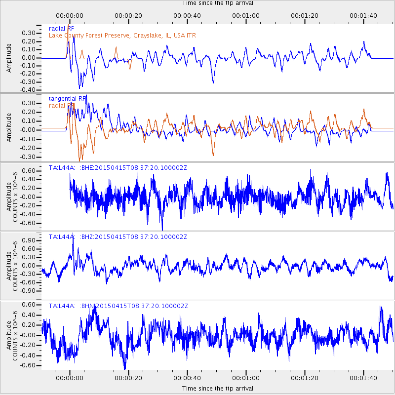
L44A Lake County Forest Preserve, Grayslake, IL, USA - Earthquake Result Viewer
*The percent match for this event was below the threshold and hence no stack was calculated.
| Earthquake location: |
Cyprus Region |
| Earthquake latitude/longitude: |
34.9/32.3 |
| Earthquake time(UTC): |
2015/04/15 (105) 08:25:12 GMT |
| Earthquake Depth: |
10 km |
| Earthquake Magnitude: |
5.5 MB |
| Earthquake Catalog/Contributor: |
NEIC PDE/NEIC COMCAT |
|
| Network: |
TA USArray Transportable Network (new EarthScope stations) |
| Station: |
L44A Lake County Forest Preserve, Grayslake, IL, USA |
| Lat/Lon: |
42.18 N/87.91 W |
| Elevation: |
202 m |
|
| Distance: |
85.8 deg |
| Az: |
319.91 deg |
| Baz: |
45.434 deg |
| Ray Param: |
$rayparam |
*The percent match for this event was below the threshold and hence was not used in the summary stack. |
|
| Radial Match: |
70.47112 % |
| Radial Bump: |
400 |
| Transverse Match: |
73.03413 % |
| Transverse Bump: |
400 |
| SOD ConfigId: |
7422571 |
| Insert Time: |
2019-04-18 05:02:43.769 +0000 |
| GWidth: |
2.5 |
| Max Bumps: |
400 |
| Tol: |
0.001 |
|
Signal To Noise
| Channel | StoN | STA | LTA |
| TA:L44A: :BHZ:20150415T08:37:20.100002Z | 2.165836 | 3.6899428E-7 | 1.7037036E-7 |
| TA:L44A: :BHN:20150415T08:37:20.100002Z | 1.2861142 | 3.075677E-7 | 2.3914492E-7 |
| TA:L44A: :BHE:20150415T08:37:20.100002Z | 1.3717694 | 2.4514196E-7 | 1.7870494E-7 |
| Arrivals |
| Ps | |
| PpPs | |
| PsPs/PpSs | |


