You are here: Home > Network List > TA - USArray Transportable Network (new EarthScope stations) Stations List
> Station R56A Bull Pasture Mountain, McDowell, VA, USA > Earthquake Result Viewer
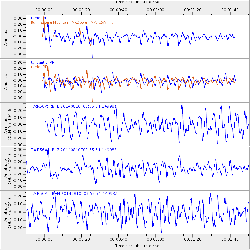
R56A Bull Pasture Mountain, McDowell, VA, USA - Earthquake Result Viewer
*The percent match for this event was below the threshold and hence no stack was calculated.
| Earthquake location: |
Hokkaido, Japan Region |
| Earthquake latitude/longitude: |
41.1/142.2 |
| Earthquake time(UTC): |
2014/08/10 (222) 03:43:16 GMT |
| Earthquake Depth: |
38 km |
| Earthquake Magnitude: |
6.0 MB |
| Earthquake Catalog/Contributor: |
NEIC PDE/NEIC COMCAT |
|
| Network: |
TA USArray Transportable Network (new EarthScope stations) |
| Station: |
R56A Bull Pasture Mountain, McDowell, VA, USA |
| Lat/Lon: |
38.41 N/79.40 W |
| Elevation: |
902 m |
|
| Distance: |
92.2 deg |
| Az: |
31.448 deg |
| Baz: |
329.897 deg |
| Ray Param: |
$rayparam |
*The percent match for this event was below the threshold and hence was not used in the summary stack. |
|
| Radial Match: |
64.905876 % |
| Radial Bump: |
400 |
| Transverse Match: |
54.382294 % |
| Transverse Bump: |
340 |
| SOD ConfigId: |
769524 |
| Insert Time: |
2014-08-24 05:00:56.845 +0000 |
| GWidth: |
2.5 |
| Max Bumps: |
400 |
| Tol: |
0.001 |
|
Signal To Noise
| Channel | StoN | STA | LTA |
| TA:R56A: :BHZ:20140810T03:55:51.14998Z | 2.4595706 | 2.8668208E-7 | 1.16557786E-7 |
| TA:R56A: :BHN:20140810T03:55:51.14998Z | 1.4754515 | 9.237983E-8 | 6.261123E-8 |
| TA:R56A: :BHE:20140810T03:55:51.14998Z | 0.9637815 | 1.0849787E-7 | 1.1257517E-7 |
| Arrivals |
| Ps | |
| PpPs | |
| PsPs/PpSs | |


