You are here: Home > Network List > TA - USArray Transportable Network (new EarthScope stations) Stations List
> Station V57A Coltrane Farms, NC, USA > Earthquake Result Viewer
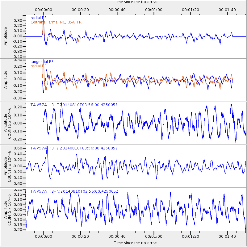
V57A Coltrane Farms, NC, USA - Earthquake Result Viewer
*The percent match for this event was below the threshold and hence no stack was calculated.
| Earthquake location: |
Hokkaido, Japan Region |
| Earthquake latitude/longitude: |
41.1/142.2 |
| Earthquake time(UTC): |
2014/08/10 (222) 03:43:16 GMT |
| Earthquake Depth: |
38 km |
| Earthquake Magnitude: |
6.0 MB |
| Earthquake Catalog/Contributor: |
NEIC PDE/NEIC COMCAT |
|
| Network: |
TA USArray Transportable Network (new EarthScope stations) |
| Station: |
V57A Coltrane Farms, NC, USA |
| Lat/Lon: |
35.89 N/79.78 W |
| Elevation: |
223 m |
|
| Distance: |
94.2 deg |
| Az: |
32.974 deg |
| Baz: |
329.588 deg |
| Ray Param: |
$rayparam |
*The percent match for this event was below the threshold and hence was not used in the summary stack. |
|
| Radial Match: |
61.80565 % |
| Radial Bump: |
344 |
| Transverse Match: |
59.444286 % |
| Transverse Bump: |
342 |
| SOD ConfigId: |
769524 |
| Insert Time: |
2014-08-24 05:03:53.888 +0000 |
| GWidth: |
2.5 |
| Max Bumps: |
400 |
| Tol: |
0.001 |
|
Signal To Noise
| Channel | StoN | STA | LTA |
| TA:V57A: :BHZ:20140810T03:56:00.425005Z | 3.1465557 | 3.087692E-7 | 9.812926E-8 |
| TA:V57A: :BHN:20140810T03:56:00.425005Z | 0.7828521 | 4.62539E-8 | 5.9083828E-8 |
| TA:V57A: :BHE:20140810T03:56:00.425005Z | 0.5240669 | 5.5914366E-8 | 1.0669318E-7 |
| Arrivals |
| Ps | |
| PpPs | |
| PsPs/PpSs | |


