You are here: Home > Network List > TA - USArray Transportable Network (new EarthScope stations) Stations List
> Station Z41A Richland Creek Farm, El Dorado, AR, USA > Earthquake Result Viewer
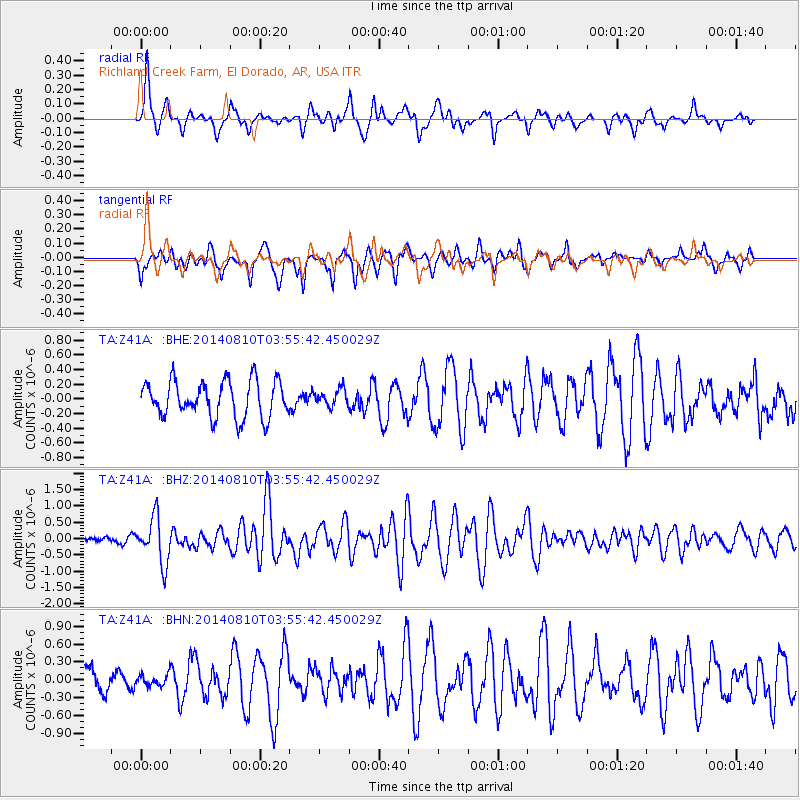
Z41A Richland Creek Farm, El Dorado, AR, USA - Earthquake Result Viewer
*The percent match for this event was below the threshold and hence no stack was calculated.
| Earthquake location: |
Hokkaido, Japan Region |
| Earthquake latitude/longitude: |
41.1/142.2 |
| Earthquake time(UTC): |
2014/08/10 (222) 03:43:16 GMT |
| Earthquake Depth: |
38 km |
| Earthquake Magnitude: |
6.0 MB |
| Earthquake Catalog/Contributor: |
NEIC PDE/NEIC COMCAT |
|
| Network: |
TA USArray Transportable Network (new EarthScope stations) |
| Station: |
Z41A Richland Creek Farm, El Dorado, AR, USA |
| Lat/Lon: |
33.26 N/92.80 W |
| Elevation: |
62 m |
|
| Distance: |
90.3 deg |
| Az: |
43.326 deg |
| Baz: |
321.794 deg |
| Ray Param: |
$rayparam |
*The percent match for this event was below the threshold and hence was not used in the summary stack. |
|
| Radial Match: |
65.39263 % |
| Radial Bump: |
347 |
| Transverse Match: |
65.70345 % |
| Transverse Bump: |
400 |
| SOD ConfigId: |
769524 |
| Insert Time: |
2014-08-24 05:05:35.959 +0000 |
| GWidth: |
2.5 |
| Max Bumps: |
400 |
| Tol: |
0.001 |
|
Signal To Noise
| Channel | StoN | STA | LTA |
| TA:Z41A: :BHZ:20140810T03:55:42.450029Z | 7.0689225 | 7.0645933E-7 | 9.993876E-8 |
| TA:Z41A: :BHN:20140810T03:55:42.450029Z | 0.36172855 | 9.71283E-8 | 2.6851157E-7 |
| TA:Z41A: :BHE:20140810T03:55:42.450029Z | 0.4569759 | 1.1288191E-7 | 2.470194E-7 |
| Arrivals |
| Ps | |
| PpPs | |
| PsPs/PpSs | |


