You are here: Home > Network List > US - United States National Seismic Network Stations List
> Station AMTX Amarillo, Texas, USA > Earthquake Result Viewer
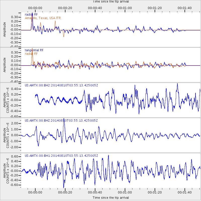
AMTX Amarillo, Texas, USA - Earthquake Result Viewer
*The percent match for this event was below the threshold and hence no stack was calculated.
| Earthquake location: |
Hokkaido, Japan Region |
| Earthquake latitude/longitude: |
41.1/142.2 |
| Earthquake time(UTC): |
2014/08/10 (222) 03:43:16 GMT |
| Earthquake Depth: |
38 km |
| Earthquake Magnitude: |
6.0 MB |
| Earthquake Catalog/Contributor: |
NEIC PDE/NEIC COMCAT |
|
| Network: |
US United States National Seismic Network |
| Station: |
AMTX Amarillo, Texas, USA |
| Lat/Lon: |
34.53 N/101.41 W |
| Elevation: |
1010 m |
|
| Distance: |
84.7 deg |
| Az: |
47.948 deg |
| Baz: |
317.212 deg |
| Ray Param: |
$rayparam |
*The percent match for this event was below the threshold and hence was not used in the summary stack. |
|
| Radial Match: |
83.71451 % |
| Radial Bump: |
369 |
| Transverse Match: |
84.6207 % |
| Transverse Bump: |
400 |
| SOD ConfigId: |
769524 |
| Insert Time: |
2014-08-24 05:06:56.237 +0000 |
| GWidth: |
2.5 |
| Max Bumps: |
400 |
| Tol: |
0.001 |
|
Signal To Noise
| Channel | StoN | STA | LTA |
| US:AMTX:00:BHZ:20140810T03:55:13.425005Z | 8.803816 | 8.683108E-7 | 9.862891E-8 |
| US:AMTX:00:BH1:20140810T03:55:13.425005Z | 1.8185762 | 1.6028612E-7 | 8.813824E-8 |
| US:AMTX:00:BH2:20140810T03:55:13.425005Z | 2.7662566 | 2.0161757E-7 | 7.2884625E-8 |
| Arrivals |
| Ps | |
| PpPs | |
| PsPs/PpSs | |


