You are here: Home > Network List > US - United States National Seismic Network Stations List
> Station CBKS Cedar Bluff, Kansas, USA > Earthquake Result Viewer
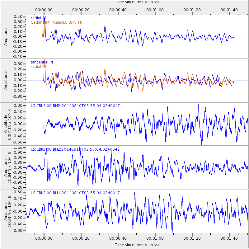
CBKS Cedar Bluff, Kansas, USA - Earthquake Result Viewer
*The percent match for this event was below the threshold and hence no stack was calculated.
| Earthquake location: |
Hokkaido, Japan Region |
| Earthquake latitude/longitude: |
41.1/142.2 |
| Earthquake time(UTC): |
2014/08/10 (222) 03:43:16 GMT |
| Earthquake Depth: |
38 km |
| Earthquake Magnitude: |
6.0 MB |
| Earthquake Catalog/Contributor: |
NEIC PDE/NEIC COMCAT |
|
| Network: |
US United States National Seismic Network |
| Station: |
CBKS Cedar Bluff, Kansas, USA |
| Lat/Lon: |
38.81 N/99.74 W |
| Elevation: |
677 m |
|
| Distance: |
82.5 deg |
| Az: |
44.044 deg |
| Baz: |
317.77 deg |
| Ray Param: |
$rayparam |
*The percent match for this event was below the threshold and hence was not used in the summary stack. |
|
| Radial Match: |
69.517624 % |
| Radial Bump: |
400 |
| Transverse Match: |
62.369255 % |
| Transverse Bump: |
400 |
| SOD ConfigId: |
769524 |
| Insert Time: |
2014-08-24 05:07:20.787 +0000 |
| GWidth: |
2.5 |
| Max Bumps: |
400 |
| Tol: |
0.001 |
|
Signal To Noise
| Channel | StoN | STA | LTA |
| US:CBKS:00:BHZ:20140810T03:55:04.024004Z | 4.860363 | 5.372892E-7 | 1.1054508E-7 |
| US:CBKS:00:BH1:20140810T03:55:04.024004Z | 1.4578444 | 2.6549318E-7 | 1.8211354E-7 |
| US:CBKS:00:BH2:20140810T03:55:04.024004Z | 1.5704069 | 1.7376901E-7 | 1.1065222E-7 |
| Arrivals |
| Ps | |
| PpPs | |
| PsPs/PpSs | |


