You are here: Home > Network List > US - United States National Seismic Network Stations List
> Station WMOK Wichita Mountains, Oklahoma, USA > Earthquake Result Viewer
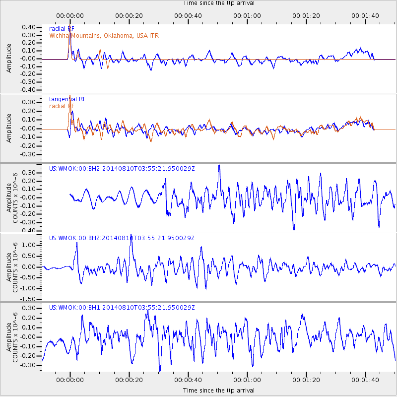
WMOK Wichita Mountains, Oklahoma, USA - Earthquake Result Viewer
*The percent match for this event was below the threshold and hence no stack was calculated.
| Earthquake location: |
Hokkaido, Japan Region |
| Earthquake latitude/longitude: |
41.1/142.2 |
| Earthquake time(UTC): |
2014/08/10 (222) 03:43:16 GMT |
| Earthquake Depth: |
38 km |
| Earthquake Magnitude: |
6.0 MB |
| Earthquake Catalog/Contributor: |
NEIC PDE/NEIC COMCAT |
|
| Network: |
US United States National Seismic Network |
| Station: |
WMOK Wichita Mountains, Oklahoma, USA |
| Lat/Lon: |
34.74 N/98.78 W |
| Elevation: |
486 m |
|
| Distance: |
86.0 deg |
| Az: |
46.196 deg |
| Baz: |
318.557 deg |
| Ray Param: |
$rayparam |
*The percent match for this event was below the threshold and hence was not used in the summary stack. |
|
| Radial Match: |
65.61344 % |
| Radial Bump: |
400 |
| Transverse Match: |
70.79709 % |
| Transverse Bump: |
400 |
| SOD ConfigId: |
769524 |
| Insert Time: |
2014-08-24 05:10:15.077 +0000 |
| GWidth: |
2.5 |
| Max Bumps: |
400 |
| Tol: |
0.001 |
|
Signal To Noise
| Channel | StoN | STA | LTA |
| US:WMOK:00:BHZ:20140810T03:55:21.950029Z | 6.706437 | 4.760005E-7 | 7.097666E-8 |
| US:WMOK:00:BH1:20140810T03:55:21.950029Z | 1.2769115 | 1.3964939E-7 | 1.0936497E-7 |
| US:WMOK:00:BH2:20140810T03:55:21.950029Z | 2.2147193 | 1.2935469E-7 | 5.8406805E-8 |
| Arrivals |
| Ps | |
| PpPs | |
| PsPs/PpSs | |


