You are here: Home > Network List > UU - University of Utah Regional Network Stations List
> Station KNB Kanab, UT, USA > Earthquake Result Viewer
KNB Kanab, UT, USA - Earthquake Result Viewer
| Earthquake location: |
Hokkaido, Japan Region |
| Earthquake latitude/longitude: |
41.1/142.2 |
| Earthquake time(UTC): |
2014/08/10 (222) 03:43:16 GMT |
| Earthquake Depth: |
38 km |
| Earthquake Magnitude: |
6.0 MB |
| Earthquake Catalog/Contributor: |
NEIC PDE/NEIC COMCAT |
|
| Network: |
UU University of Utah Regional Network |
| Station: |
KNB Kanab, UT, USA |
| Lat/Lon: |
37.02 N/112.82 W |
| Elevation: |
1715 m |
|
| Distance: |
76.3 deg |
| Az: |
52.716 deg |
| Baz: |
311.342 deg |
| Ray Param: |
0.05100956 |
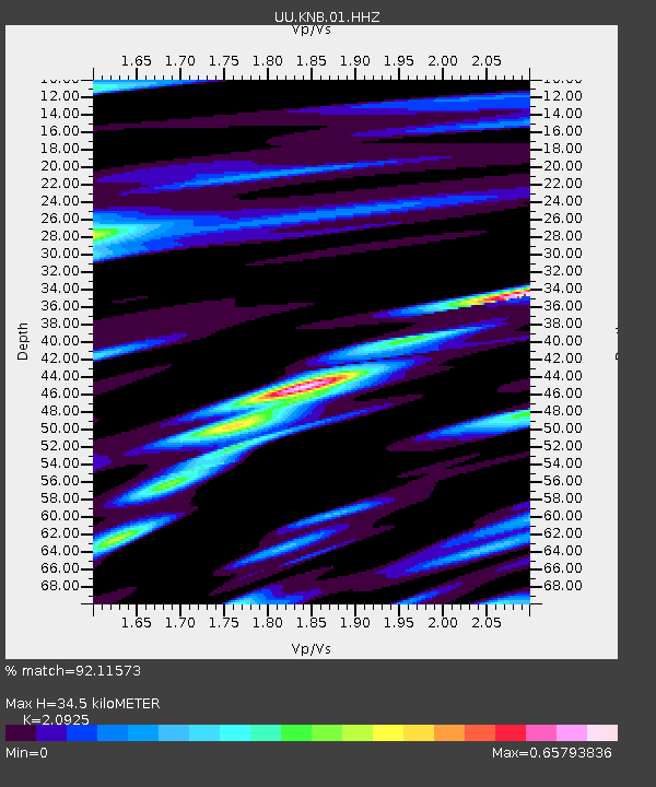
| Estimated Moho Depth: |
34.5 km |
| Estimated Crust Vp/Vs: |
2.09 |
| Assumed Crust Vp: |
6.194 km/s |
| Estimated Crust Vs: |
2.96 km/s |
| Estimated Crust Poisson's Ratio: |
0.35 |
|
| Radial Match: |
92.11573 % |
| Radial Bump: |
340 |
| Transverse Match: |
80.47365 % |
| Transverse Bump: |
387 |
| SOD ConfigId: |
769524 |
| Insert Time: |
2014-08-24 05:11:15.169 +0000 |
| GWidth: |
2.5 |
| Max Bumps: |
400 |
| Tol: |
0.001 |
|

Signal To Noise
| Channel | StoN | STA | LTA |
| UU:KNB:01:HHZ:20140810T03:54:30.789995Z | 11.969742 | 2.2896314E-8 | 1.9128494E-9 |
| UU:KNB:01:HHN:20140810T03:54:30.789995Z | 3.8762612 | 8.113607E-9 | 2.0931528E-9 |
| UU:KNB:01:HHE:20140810T03:54:30.789995Z | 3.208175 | 6.152891E-9 | 1.917879E-9 |
| Arrivals |
| Ps | 6.2 SECOND |
| PpPs | 17 SECOND |
| PsPs/PpSs | 23 SECOND |


