You are here: Home > Network List > UW - Pacific Northwest Regional Seismic Network Stations List
> Station MRBL Marblemount, WA, USA > Earthquake Result Viewer
MRBL Marblemount, WA, USA - Earthquake Result Viewer
| Earthquake location: |
Hokkaido, Japan Region |
| Earthquake latitude/longitude: |
41.1/142.2 |
| Earthquake time(UTC): |
2014/08/10 (222) 03:43:16 GMT |
| Earthquake Depth: |
38 km |
| Earthquake Magnitude: |
6.0 MB |
| Earthquake Catalog/Contributor: |
NEIC PDE/NEIC COMCAT |
|
| Network: |
UW Pacific Northwest Regional Seismic Network |
| Station: |
MRBL Marblemount, WA, USA |
| Lat/Lon: |
48.52 N/121.48 W |
| Elevation: |
75 m |
|
| Distance: |
64.3 deg |
| Az: |
47.181 deg |
| Baz: |
303.568 deg |
| Ray Param: |
0.058961052 |
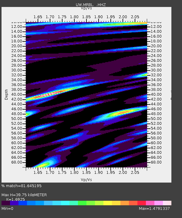
| Estimated Moho Depth: |
39.75 km |
| Estimated Crust Vp/Vs: |
1.69 |
| Assumed Crust Vp: |
6.566 km/s |
| Estimated Crust Vs: |
3.88 km/s |
| Estimated Crust Poisson's Ratio: |
0.23 |
|
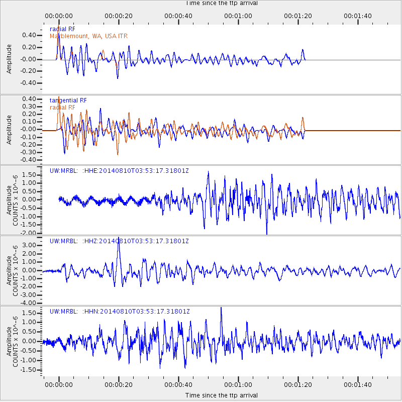
| Radial Match: |
81.645195 % |
| Radial Bump: |
400 |
| Transverse Match: |
87.81588 % |
| Transverse Bump: |
400 |
| SOD ConfigId: |
769524 |
| Insert Time: |
2014-08-24 05:13:38.496 +0000 |
| GWidth: |
2.5 |
| Max Bumps: |
400 |
| Tol: |
0.001 |
|
Signal To Noise
| Channel | StoN | STA | LTA |
| UW:MRBL: :HHZ:20140810T03:53:17.31801Z | 9.765918 | 5.601449E-7 | 5.735712E-8 |
| UW:MRBL: :HHN:20140810T03:53:17.31801Z | 1.9711753 | 1.9605308E-7 | 9.945999E-8 |
| UW:MRBL: :HHE:20140810T03:53:17.31801Z | 1.5334697 | 2.3248944E-7 | 1.5161007E-7 |
| Arrivals |
| Ps | 4.4 SECOND |
| PpPs | 16 SECOND |
| PsPs/PpSs | 20 SECOND |


