You are here: Home > Network List > UW - Pacific Northwest Regional Seismic Network Stations List
> Station LEBA Lebam, WA, USA > Earthquake Result Viewer
LEBA Lebam, WA, USA - Earthquake Result Viewer
*The percent match for this event was below the threshold and hence no stack was calculated.
| Earthquake location: |
Kermadec Islands Region |
| Earthquake latitude/longitude: |
-29.7/-176.1 |
| Earthquake time(UTC): |
2014/08/11 (223) 10:07:37 GMT |
| Earthquake Depth: |
32 km |
| Earthquake Magnitude: |
5.5 MB |
| Earthquake Catalog/Contributor: |
NEIC PDE/NEIC COMCAT |
|
| Network: |
UW Pacific Northwest Regional Seismic Network |
| Station: |
LEBA Lebam, WA, USA |
| Lat/Lon: |
46.55 N/123.56 W |
| Elevation: |
73 m |
|
| Distance: |
89.5 deg |
| Az: |
33.207 deg |
| Baz: |
223.634 deg |
| Ray Param: |
$rayparam |
*The percent match for this event was below the threshold and hence was not used in the summary stack. |
|
| Radial Match: |
54.61397 % |
| Radial Bump: |
373 |
| Transverse Match: |
59.800438 % |
| Transverse Bump: |
400 |
| SOD ConfigId: |
769524 |
| Insert Time: |
2014-08-25 10:31:24.517 +0000 |
| GWidth: |
2.5 |
| Max Bumps: |
400 |
| Tol: |
0.001 |
|
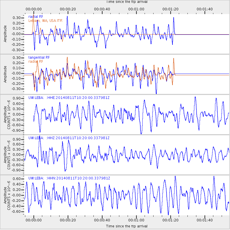
Signal To Noise
| Channel | StoN | STA | LTA |
| UW:LEBA: :HHZ:20140811T10:20:00.337981Z | 2.6486838 | 4.6782245E-7 | 1.766245E-7 |
| UW:LEBA: :HHN:20140811T10:20:00.337981Z | 1.3412597 | 2.8447093E-7 | 2.1209236E-7 |
| UW:LEBA: :HHE:20140811T10:20:00.337981Z | 1.462315 | 4.5890874E-7 | 3.1382345E-7 |
| Arrivals |
| Ps | |
| PpPs | |
| PsPs/PpSs | |


