You are here: Home > Network List > G - GEOSCOPE Stations List
> Station MPG Montagne des Peres, French Guyana > Earthquake Result Viewer
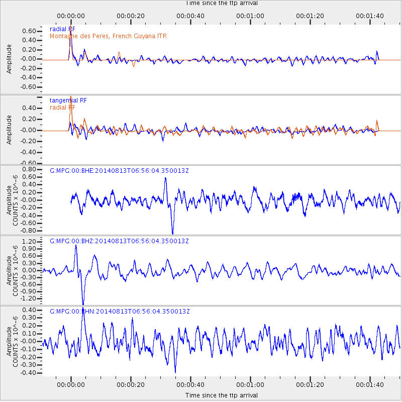
MPG Montagne des Peres, French Guyana - Earthquake Result Viewer
*The percent match for this event was below the threshold and hence no stack was calculated.
| Earthquake location: |
Near Coast Of Guerrero, Mexico |
| Earthquake latitude/longitude: |
16.3/-98.2 |
| Earthquake time(UTC): |
2014/08/13 (225) 06:48:11 GMT |
| Earthquake Depth: |
10 km |
| Earthquake Magnitude: |
5.8 MWP |
| Earthquake Catalog/Contributor: |
NEIC PDE/NEIC COMCAT |
|
| Network: |
G GEOSCOPE |
| Station: |
MPG Montagne des Peres, French Guyana |
| Lat/Lon: |
5.11 N/52.64 W |
| Elevation: |
147 m |
|
| Distance: |
46.0 deg |
| Az: |
98.814 deg |
| Baz: |
287.731 deg |
| Ray Param: |
$rayparam |
*The percent match for this event was below the threshold and hence was not used in the summary stack. |
|
| Radial Match: |
70.643875 % |
| Radial Bump: |
400 |
| Transverse Match: |
50.744514 % |
| Transverse Bump: |
400 |
| SOD ConfigId: |
769524 |
| Insert Time: |
2014-08-27 07:17:26.700 +0000 |
| GWidth: |
2.5 |
| Max Bumps: |
400 |
| Tol: |
0.001 |
|
Signal To Noise
| Channel | StoN | STA | LTA |
| G:MPG:00:BHZ:20140813T06:56:04.350013Z | 5.9372516 | 6.1585934E-7 | 1.0372801E-7 |
| G:MPG:00:BHN:20140813T06:56:04.350013Z | 2.6294634 | 1.8346192E-7 | 6.9771616E-8 |
| G:MPG:00:BHE:20140813T06:56:04.350013Z | 3.0117083 | 3.5574305E-7 | 1.18120035E-7 |
| Arrivals |
| Ps | |
| PpPs | |
| PsPs/PpSs | |


