You are here: Home > Network List > II - Global Seismograph Network (GSN - IRIS/IDA) Stations List
> Station CMLA Cha de Macela, Sao Miguel Island, Azores > Earthquake Result Viewer
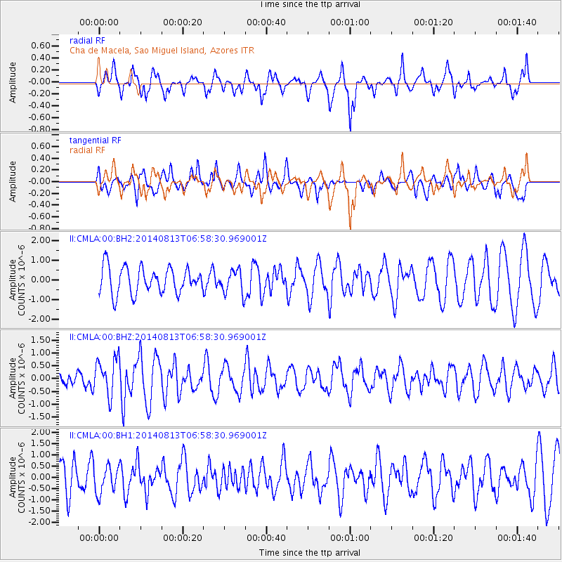
CMLA Cha de Macela, Sao Miguel Island, Azores - Earthquake Result Viewer
*The percent match for this event was below the threshold and hence no stack was calculated.
| Earthquake location: |
Near Coast Of Guerrero, Mexico |
| Earthquake latitude/longitude: |
16.3/-98.2 |
| Earthquake time(UTC): |
2014/08/13 (225) 06:48:11 GMT |
| Earthquake Depth: |
10 km |
| Earthquake Magnitude: |
5.8 MWP |
| Earthquake Catalog/Contributor: |
NEIC PDE/NEIC COMCAT |
|
| Network: |
II Global Seismograph Network (GSN - IRIS/IDA) |
| Station: |
CMLA Cha de Macela, Sao Miguel Island, Azores |
| Lat/Lon: |
37.76 N/25.52 W |
| Elevation: |
429 m |
|
| Distance: |
66.6 deg |
| Az: |
55.526 deg |
| Baz: |
272.933 deg |
| Ray Param: |
$rayparam |
*The percent match for this event was below the threshold and hence was not used in the summary stack. |
|
| Radial Match: |
75.47831 % |
| Radial Bump: |
400 |
| Transverse Match: |
54.91137 % |
| Transverse Bump: |
380 |
| SOD ConfigId: |
769524 |
| Insert Time: |
2014-08-27 07:19:46.798 +0000 |
| GWidth: |
2.5 |
| Max Bumps: |
400 |
| Tol: |
0.001 |
|
Signal To Noise
| Channel | StoN | STA | LTA |
| II:CMLA:00:BHZ:20140813T06:58:30.969001Z | 2.569731 | 7.3677893E-7 | 2.867144E-7 |
| II:CMLA:00:BH1:20140813T06:58:30.969001Z | 0.5206242 | 5.974188E-7 | 1.1475048E-6 |
| II:CMLA:00:BH2:20140813T06:58:30.969001Z | 0.9277678 | 6.2273676E-7 | 6.7122045E-7 |
| Arrivals |
| Ps | |
| PpPs | |
| PsPs/PpSs | |


