You are here: Home > Network List > TA - USArray Transportable Network (new EarthScope stations) Stations List
> Station A04D Lummi Island, WA, USA > Earthquake Result Viewer
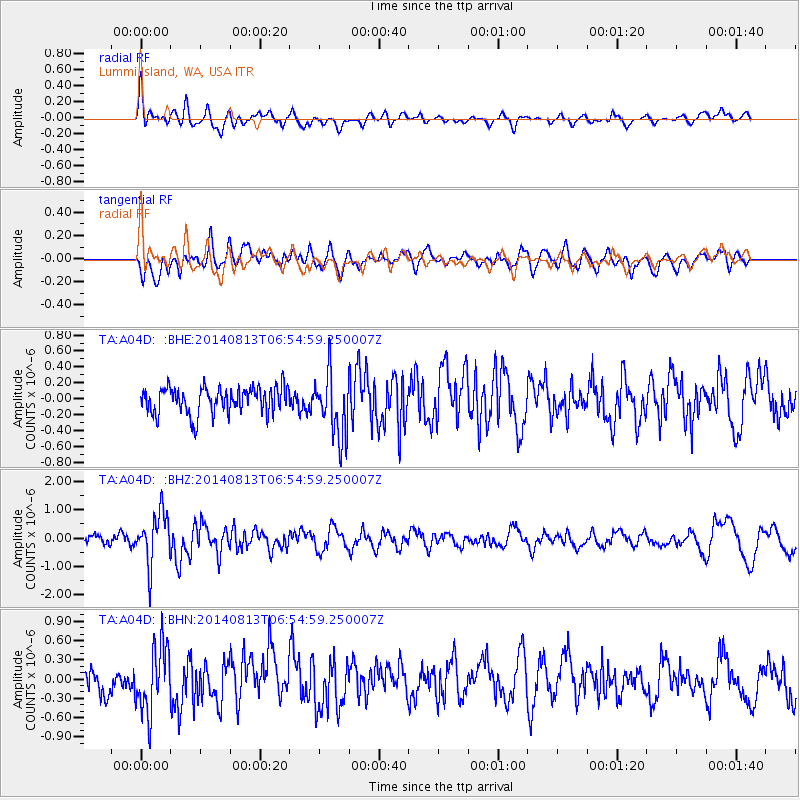
A04D Lummi Island, WA, USA - Earthquake Result Viewer
*The percent match for this event was below the threshold and hence no stack was calculated.
| Earthquake location: |
Near Coast Of Guerrero, Mexico |
| Earthquake latitude/longitude: |
16.3/-98.2 |
| Earthquake time(UTC): |
2014/08/13 (225) 06:48:11 GMT |
| Earthquake Depth: |
10 km |
| Earthquake Magnitude: |
5.8 MWP |
| Earthquake Catalog/Contributor: |
NEIC PDE/NEIC COMCAT |
|
| Network: |
TA USArray Transportable Network (new EarthScope stations) |
| Station: |
A04D Lummi Island, WA, USA |
| Lat/Lon: |
48.72 N/122.71 W |
| Elevation: |
13 m |
|
| Distance: |
38.0 deg |
| Az: |
333.471 deg |
| Baz: |
139.642 deg |
| Ray Param: |
$rayparam |
*The percent match for this event was below the threshold and hence was not used in the summary stack. |
|
| Radial Match: |
62.831738 % |
| Radial Bump: |
400 |
| Transverse Match: |
53.34381 % |
| Transverse Bump: |
400 |
| SOD ConfigId: |
769524 |
| Insert Time: |
2014-08-27 07:31:43.326 +0000 |
| GWidth: |
2.5 |
| Max Bumps: |
400 |
| Tol: |
0.001 |
|
Signal To Noise
| Channel | StoN | STA | LTA |
| TA:A04D: :BHZ:20140813T06:54:59.250007Z | 6.470625 | 9.03424E-7 | 1.3961927E-7 |
| TA:A04D: :BHN:20140813T06:54:59.250007Z | 2.8289866 | 5.3174546E-7 | 1.8796324E-7 |
| TA:A04D: :BHE:20140813T06:54:59.250007Z | 2.3666306 | 3.953522E-7 | 1.6705276E-7 |
| Arrivals |
| Ps | |
| PpPs | |
| PsPs/PpSs | |


