You are here: Home > Network List > TA - USArray Transportable Network (new EarthScope stations) Stations List
> Station F05D White Salmon, WA, USA > Earthquake Result Viewer
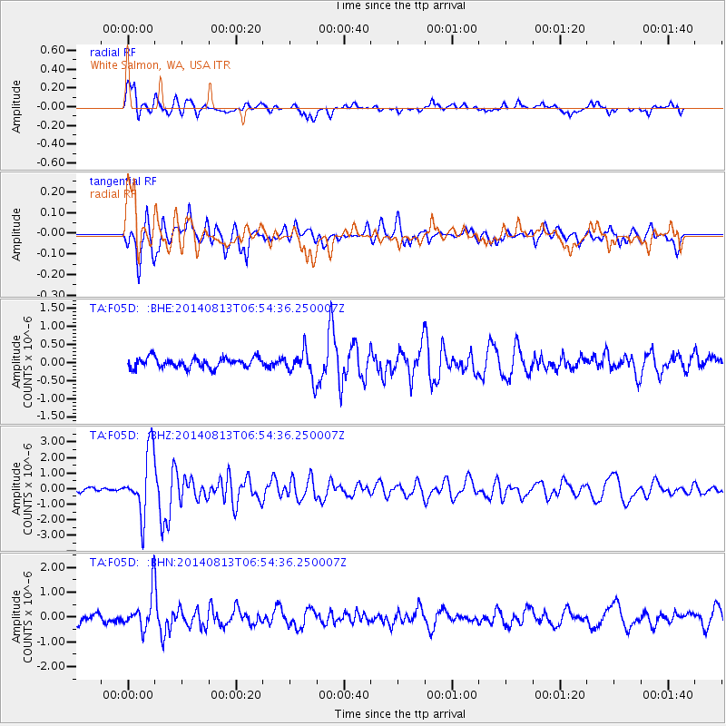
F05D White Salmon, WA, USA - Earthquake Result Viewer

| Earthquake location: |
Near Coast Of Guerrero, Mexico |
| Earthquake latitude/longitude: |
16.3/-98.2 |
| Earthquake time(UTC): |
2014/08/13 (225) 06:48:11 GMT |
| Earthquake Depth: |
10 km |
| Earthquake Magnitude: |
5.8 MWP |
| Earthquake Catalog/Contributor: |
NEIC PDE/NEIC COMCAT |
|
| Network: |
TA USArray Transportable Network (new EarthScope stations) |
| Station: |
F05D White Salmon, WA, USA |
| Lat/Lon: |
45.89 N/121.46 W |
| Elevation: |
472 m |
|
| Distance: |
35.3 deg |
| Az: |
331.449 deg |
| Baz: |
138.934 deg |
| Ray Param: |
0.077293746 |
| Estimated Moho Depth: |
59.75 km |
| Estimated Crust Vp/Vs: |
1.91 |
| Assumed Crust Vp: |
6.597 km/s |
| Estimated Crust Vs: |
3.454 km/s |
| Estimated Crust Poisson's Ratio: |
0.31 |
|
| Radial Match: |
82.37821 % |
| Radial Bump: |
400 |
| Transverse Match: |
81.569405 % |
| Transverse Bump: |
400 |
| SOD ConfigId: |
769524 |
| Insert Time: |
2014-08-27 07:37:44.779 +0000 |
| GWidth: |
2.5 |
| Max Bumps: |
400 |
| Tol: |
0.001 |
|
Signal To Noise
| Channel | StoN | STA | LTA |
| TA:F05D: :BHZ:20140813T06:54:36.250007Z | 10.588531 | 2.0379616E-6 | 1.9246879E-7 |
| TA:F05D: :BHN:20140813T06:54:36.250007Z | 4.2536483 | 7.34741E-7 | 1.7273196E-7 |
| TA:F05D: :BHE:20140813T06:54:36.250007Z | 2.775697 | 3.887916E-7 | 1.400699E-7 |
| Arrivals |
| Ps | 8.9 SECOND |
| PpPs | 24 SECOND |
| PsPs/PpSs | 33 SECOND |


