You are here: Home > Network List > TA - USArray Transportable Network (new EarthScope stations) Stations List
> Station G63A Kingsbury, ME, USA > Earthquake Result Viewer
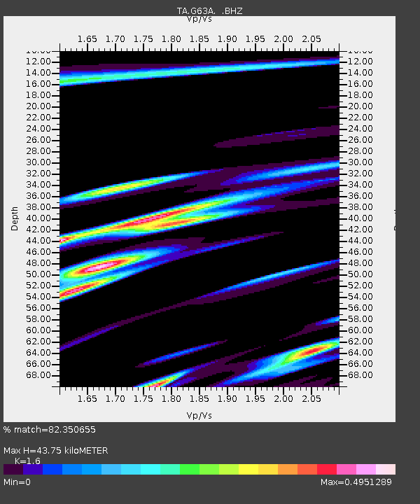
G63A Kingsbury, ME, USA - Earthquake Result Viewer
| Earthquake location: |
Near Coast Of Guerrero, Mexico |
| Earthquake latitude/longitude: |
16.3/-98.2 |
| Earthquake time(UTC): |
2014/08/13 (225) 06:48:11 GMT |
| Earthquake Depth: |
10 km |
| Earthquake Magnitude: |
5.8 MWP |
| Earthquake Catalog/Contributor: |
NEIC PDE/NEIC COMCAT |
|
| Network: |
TA USArray Transportable Network (new EarthScope stations) |
| Station: |
G63A Kingsbury, ME, USA |
| Lat/Lon: |
45.11 N/69.62 W |
| Elevation: |
363 m |
|
| Distance: |
37.4 deg |
| Az: |
33.875 deg |
| Baz: |
229.094 deg |
| Ray Param: |
0.07616769 |
| Estimated Moho Depth: |
43.75 km |
| Estimated Crust Vp/Vs: |
1.60 |
| Assumed Crust Vp: |
6.419 km/s |
| Estimated Crust Vs: |
4.012 km/s |
| Estimated Crust Poisson's Ratio: |
0.18 |
|
| Radial Match: |
82.350655 % |
| Radial Bump: |
340 |
| Transverse Match: |
67.0587 % |
| Transverse Bump: |
400 |
| SOD ConfigId: |
769524 |
| Insert Time: |
2014-08-27 07:39:01.889 +0000 |
| GWidth: |
2.5 |
| Max Bumps: |
400 |
| Tol: |
0.001 |
|

Signal To Noise
| Channel | StoN | STA | LTA |
| TA:G63A: :BHZ:20140813T06:54:53.924995Z | 2.759717 | 3.0298037E-7 | 1.0978675E-7 |
| TA:G63A: :BHN:20140813T06:54:53.924995Z | 1.0082399 | 1.05492965E-7 | 1.0463082E-7 |
| TA:G63A: :BHE:20140813T06:54:53.924995Z | 1.5830945 | 2.013976E-7 | 1.2721767E-7 |
| Arrivals |
| Ps | 4.4 SECOND |
| PpPs | 16 SECOND |
| PsPs/PpSs | 21 SECOND |


