You are here: Home > Network List > TA - USArray Transportable Network (new EarthScope stations) Stations List
> Station J01E Myrtle Point, OR, USA > Earthquake Result Viewer
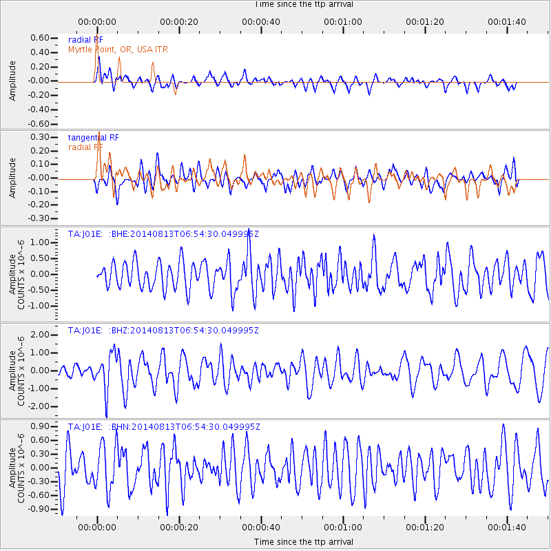
J01E Myrtle Point, OR, USA - Earthquake Result Viewer
*The percent match for this event was below the threshold and hence no stack was calculated.
| Earthquake location: |
Near Coast Of Guerrero, Mexico |
| Earthquake latitude/longitude: |
16.3/-98.2 |
| Earthquake time(UTC): |
2014/08/13 (225) 06:48:11 GMT |
| Earthquake Depth: |
10 km |
| Earthquake Magnitude: |
5.8 MWP |
| Earthquake Catalog/Contributor: |
NEIC PDE/NEIC COMCAT |
|
| Network: |
TA USArray Transportable Network (new EarthScope stations) |
| Station: |
J01E Myrtle Point, OR, USA |
| Lat/Lon: |
43.16 N/123.93 W |
| Elevation: |
128 m |
|
| Distance: |
34.6 deg |
| Az: |
325.921 deg |
| Baz: |
132.673 deg |
| Ray Param: |
$rayparam |
*The percent match for this event was below the threshold and hence was not used in the summary stack. |
|
| Radial Match: |
64.4299 % |
| Radial Bump: |
400 |
| Transverse Match: |
48.672966 % |
| Transverse Bump: |
400 |
| SOD ConfigId: |
769524 |
| Insert Time: |
2014-08-27 07:40:57.210 +0000 |
| GWidth: |
2.5 |
| Max Bumps: |
400 |
| Tol: |
0.001 |
|
Signal To Noise
| Channel | StoN | STA | LTA |
| TA:J01E: :BHZ:20140813T06:54:30.049995Z | 2.741091 | 1.0210067E-6 | 3.7248185E-7 |
| TA:J01E: :BHN:20140813T06:54:30.049995Z | 1.2711151 | 5.076092E-7 | 3.9934162E-7 |
| TA:J01E: :BHE:20140813T06:54:30.049995Z | 1.2048968 | 4.7032134E-7 | 3.9034157E-7 |
| Arrivals |
| Ps | |
| PpPs | |
| PsPs/PpSs | |


