You are here: Home > Network List > TA - USArray Transportable Network (new EarthScope stations) Stations List
> Station I64A Boothbay, ME, USA > Earthquake Result Viewer
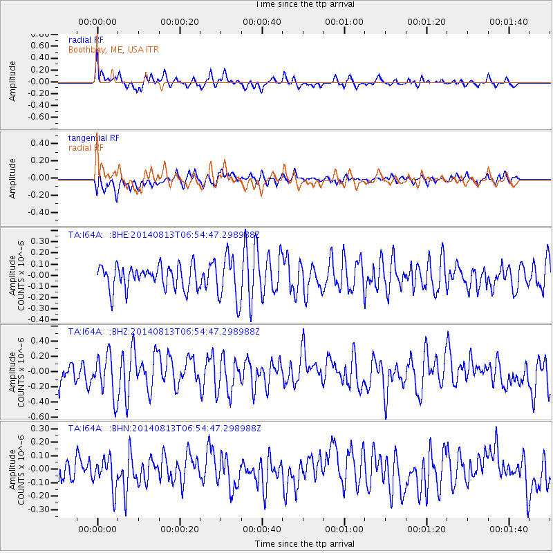
I64A Boothbay, ME, USA - Earthquake Result Viewer
*The percent match for this event was below the threshold and hence no stack was calculated.
| Earthquake location: |
Near Coast Of Guerrero, Mexico |
| Earthquake latitude/longitude: |
16.3/-98.2 |
| Earthquake time(UTC): |
2014/08/13 (225) 06:48:11 GMT |
| Earthquake Depth: |
10 km |
| Earthquake Magnitude: |
5.8 MWP |
| Earthquake Catalog/Contributor: |
NEIC PDE/NEIC COMCAT |
|
| Network: |
TA USArray Transportable Network (new EarthScope stations) |
| Station: |
I64A Boothbay, ME, USA |
| Lat/Lon: |
43.92 N/69.63 W |
| Elevation: |
17 m |
|
| Distance: |
36.6 deg |
| Az: |
35.377 deg |
| Baz: |
230.283 deg |
| Ray Param: |
$rayparam |
*The percent match for this event was below the threshold and hence was not used in the summary stack. |
|
| Radial Match: |
64.27179 % |
| Radial Bump: |
400 |
| Transverse Match: |
64.029335 % |
| Transverse Bump: |
400 |
| SOD ConfigId: |
769524 |
| Insert Time: |
2014-08-27 07:40:57.349 +0000 |
| GWidth: |
2.5 |
| Max Bumps: |
400 |
| Tol: |
0.001 |
|
Signal To Noise
| Channel | StoN | STA | LTA |
| TA:I64A: :BHZ:20140813T06:54:47.298988Z | 2.373366 | 2.882419E-7 | 1.2144856E-7 |
| TA:I64A: :BHN:20140813T06:54:47.298988Z | 1.3863374 | 1.1693963E-7 | 8.43515E-8 |
| TA:I64A: :BHE:20140813T06:54:47.298988Z | 2.0400739 | 2.0751374E-7 | 1.0171874E-7 |
| Arrivals |
| Ps | |
| PpPs | |
| PsPs/PpSs | |


