You are here: Home > Network List > TA - USArray Transportable Network (new EarthScope stations) Stations List
> Station M04C Macdoel, CA, USA > Earthquake Result Viewer
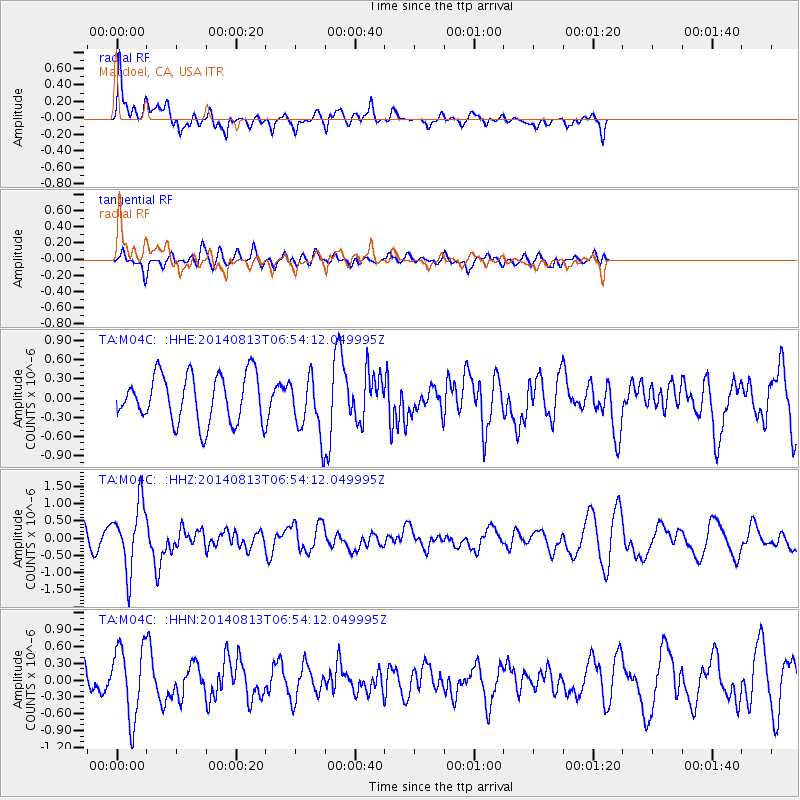
M04C Macdoel, CA, USA - Earthquake Result Viewer
*The percent match for this event was below the threshold and hence no stack was calculated.
| Earthquake location: |
Near Coast Of Guerrero, Mexico |
| Earthquake latitude/longitude: |
16.3/-98.2 |
| Earthquake time(UTC): |
2014/08/13 (225) 06:48:11 GMT |
| Earthquake Depth: |
10 km |
| Earthquake Magnitude: |
5.8 MWP |
| Earthquake Catalog/Contributor: |
NEIC PDE/NEIC COMCAT |
|
| Network: |
TA USArray Transportable Network (new EarthScope stations) |
| Station: |
M04C Macdoel, CA, USA |
| Lat/Lon: |
41.78 N/121.84 W |
| Elevation: |
1391 m |
|
| Distance: |
32.5 deg |
| Az: |
326.035 deg |
| Baz: |
134.176 deg |
| Ray Param: |
$rayparam |
*The percent match for this event was below the threshold and hence was not used in the summary stack. |
|
| Radial Match: |
67.30327 % |
| Radial Bump: |
400 |
| Transverse Match: |
43.093796 % |
| Transverse Bump: |
400 |
| SOD ConfigId: |
769524 |
| Insert Time: |
2014-08-27 07:43:32.764 +0000 |
| GWidth: |
2.5 |
| Max Bumps: |
400 |
| Tol: |
0.001 |
|
Signal To Noise
| Channel | StoN | STA | LTA |
| TA:M04C: :HHZ:20140813T06:54:12.049995Z | 3.370336 | 9.572232E-7 | 2.8401416E-7 |
| TA:M04C: :HHN:20140813T06:54:12.049995Z | 3.047425 | 6.4240663E-7 | 2.1080311E-7 |
| TA:M04C: :HHE:20140813T06:54:12.049995Z | 1.2086699 | 4.462708E-7 | 3.6922475E-7 |
| Arrivals |
| Ps | |
| PpPs | |
| PsPs/PpSs | |


