You are here: Home > Network List > TA - USArray Transportable Network (new EarthScope stations) Stations List
> Station P56A Dayton Farm, Ripley, WV, USA > Earthquake Result Viewer
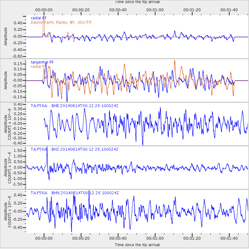
P56A Dayton Farm, Ripley, WV, USA - Earthquake Result Viewer
*The percent match for this event was below the threshold and hence no stack was calculated.
| Earthquake location: |
Northern Chile |
| Earthquake latitude/longitude: |
-20.2/-70.0 |
| Earthquake time(UTC): |
2014/08/14 (226) 00:02:55 GMT |
| Earthquake Depth: |
48 km |
| Earthquake Magnitude: |
5.7 MB |
| Earthquake Catalog/Contributor: |
NEIC PDE/NEIC COMCAT |
|
| Network: |
TA USArray Transportable Network (new EarthScope stations) |
| Station: |
P56A Dayton Farm, Ripley, WV, USA |
| Lat/Lon: |
39.50 N/78.84 W |
| Elevation: |
249 m |
|
| Distance: |
59.9 deg |
| Az: |
352.095 deg |
| Baz: |
170.386 deg |
| Ray Param: |
$rayparam |
*The percent match for this event was below the threshold and hence was not used in the summary stack. |
|
| Radial Match: |
63.14597 % |
| Radial Bump: |
400 |
| Transverse Match: |
55.22444 % |
| Transverse Bump: |
400 |
| SOD ConfigId: |
769524 |
| Insert Time: |
2014-08-28 02:04:11.291 +0000 |
| GWidth: |
2.5 |
| Max Bumps: |
400 |
| Tol: |
0.001 |
|
Signal To Noise
| Channel | StoN | STA | LTA |
| TA:P56A: :BHZ:20140814T00:12:26.100024Z | 3.050405 | 5.494343E-7 | 1.8011848E-7 |
| TA:P56A: :BHN:20140814T00:12:26.100024Z | 1.709182 | 1.5580233E-7 | 9.115608E-8 |
| TA:P56A: :BHE:20140814T00:12:26.100024Z | 0.7375367 | 1.1293185E-7 | 1.5312031E-7 |
| Arrivals |
| Ps | |
| PpPs | |
| PsPs/PpSs | |


