You are here: Home > Network List > TA - USArray Transportable Network (new EarthScope stations) Stations List
> Station Z41A Richland Creek Farm, El Dorado, AR, USA > Earthquake Result Viewer
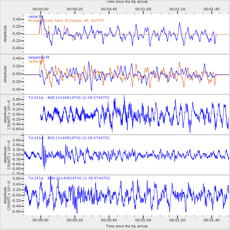
Z41A Richland Creek Farm, El Dorado, AR, USA - Earthquake Result Viewer
*The percent match for this event was below the threshold and hence no stack was calculated.
| Earthquake location: |
Northern Chile |
| Earthquake latitude/longitude: |
-20.2/-70.0 |
| Earthquake time(UTC): |
2014/08/14 (226) 00:02:55 GMT |
| Earthquake Depth: |
48 km |
| Earthquake Magnitude: |
5.7 MB |
| Earthquake Catalog/Contributor: |
NEIC PDE/NEIC COMCAT |
|
| Network: |
TA USArray Transportable Network (new EarthScope stations) |
| Station: |
Z41A Richland Creek Farm, El Dorado, AR, USA |
| Lat/Lon: |
33.26 N/92.80 W |
| Elevation: |
62 m |
|
| Distance: |
57.4 deg |
| Az: |
337.32 deg |
| Baz: |
154.384 deg |
| Ray Param: |
$rayparam |
*The percent match for this event was below the threshold and hence was not used in the summary stack. |
|
| Radial Match: |
69.82125 % |
| Radial Bump: |
400 |
| Transverse Match: |
48.7049 % |
| Transverse Bump: |
400 |
| SOD ConfigId: |
769524 |
| Insert Time: |
2014-08-28 02:10:09.563 +0000 |
| GWidth: |
2.5 |
| Max Bumps: |
400 |
| Tol: |
0.001 |
|
Signal To Noise
| Channel | StoN | STA | LTA |
| TA:Z41A: :BHZ:20140814T00:12:08.674976Z | 3.7870026 | 3.9605004E-7 | 1.0458141E-7 |
| TA:Z41A: :BHN:20140814T00:12:08.674976Z | 1.1286185 | 2.4695814E-7 | 2.1881455E-7 |
| TA:Z41A: :BHE:20140814T00:12:08.674976Z | 1.1891406 | 1.9838828E-7 | 1.6683333E-7 |
| Arrivals |
| Ps | |
| PpPs | |
| PsPs/PpSs | |


